
|
Perambulation and boundary papers
1. Perambulation of the boundaries of Mallerstang, 1651
Source: Cumbria Record Office, Kendal, WD/Hoth, boundary papers, Mallerstang
Transcript:
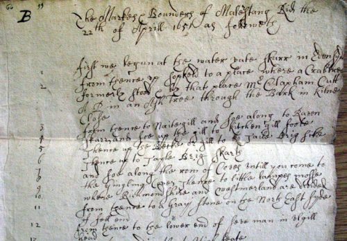
The Markes & Bounders of Mallerstang Rid the 22th of Aprill 1651 as followeth
| 1 | first we begun at the water yate skarr in Edensyde |
| 2 | from thence up sopkeld to a place where a Crabtree formerly stood & by that place Mr Clapham Cutt A P in an Ash tree through the Bark in Kilne Close |
| 3 | from thence to Naitegill and soe along to Raven |
| 4 | Skarr and soe up the gill to Kitchen gill foote |
| 5 | Thence up the Becke or gill to K [apparently a transcription error which has not been erased] Taile Brig sike |
| 6 | Thence up to Tayle Brig Skarth |
| 7 | and soe along the row of Coves untill you come to |
| 8 | the Gingling Coves, Thence to little lampes mosse |
| 9 | where Richmondshire and Westmerland are divided |
| 10 | from thence to a Gray stone on the North East syde |
| 11 | of fell end |
| 12 | from thence to the lower end of seve man in ulgill head |
Commentary:
A 'perambulation' is a description of the boundaries of a manor, often recording the boundaries as ‘beaten’ or perambulated by members of the manor court.
Recording the boundaries of a manor was of particular importance where, as was often the case in Cumbria, the manorial boundary ran across unenclosed fell, moorland or marsh. Disputes between neighbouring manors were numerous: the unenclosed commons were valuable to the manorial community as pasture and a source of fuel in the form of peat, and often to the lord for mineral rights. In the case of Mallerstang, the moorland boundary near Hellgill remained in contention in the later 18th century. This extract records the north-eastern section of the boundary ridden on behalf of the lord of Mallerstang in 1651. Notice how, at a place where a crab apple tree had formerly marked the boundary, the steward, Mr Clapham, cut a new mark, 'A P' (the initials of the lord of the manor, Lady Anne Clifford, countess of Pembroke) on an ash tree.
2. Boundaries of Muchland, Furness, 1856
[Awaiting Image]
Source: Cumbria Record Office, Barrow, BD/BUC/Perambulation maps/1
Commentary:
Maps showing manorial boundaries are comparatively rare. This is one of a series of coloured first edition Six Inch Ordnance Survey maps of Furness preserved in the Buccleuch archive, showing manorial boundaries in the mid-nineteenth century. Furness was an area where mineral rights were particularly valuable; hence the continuing significance of manorial boundaries at this late date. The pattern of boundaries on the map also illustrates the great time-depth which often lies buried behind manorial boundaries.
This extract is from the manor of Muchland (formerly called the manor of Aldingham), which originated in the lands held by Michael le Fleming ('Muchland' = 'Michael's-land') in the early thirteenth century. The outer boundaries of the manor (coloured blue) conincided with the boundaries of the parish of Aldingham and Urswick but within the outer boundary there were enclaves of land belonging to other manors. The largest of these was the subsidiary manor of Bolton-with-Adgarley (coloured yellow) which appears to have originated in a grant of land made by Michael le Fleming as a marriage portion with his daughter before 1212. It came into the hands of the earls of Derby in 1487. The scattered fields of different colours around Great Urswick were parts of the village's open fields which belonged to other manors. One of these smaller enclaves, known as Westby's Lands (or the manor of Great Urswick), was a very small manor, consisting solely of scattered parcels in Great Urswick township, which again originated in a grant of lands as a marriage portion in the twelfth century.
< Gallery
Credits: This site is maintained by Dr Angus Winchester and Dr Eleanor Straughton. For advice about access issues, please visit the Department's Accessibility Advice Page.
Copyright: Department of History, Lancaster University | Disclaimer: as per university policy.