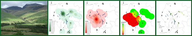
Gray & Coleridge: Comparative Maps
The decision to map out the geo-specific texts of Gray and Coleridge may seem a little arbitrary: the texts were written over thirty years apart; the accounts have contrasting, if equally convoluted, textual histories; and their composition was underpinned by different aims, ambitions and intentions. Yet this GIS pilot project is informed by the belief that comparative digital maps may highlight different spatial patterns across a range of seemingly disparate literary texts.
What happens, then, when the Gray and Coleridge GIS maps are placed alongside one another? Do these comparative maps illuminate the representations of space offered within both primary texts? By extension, do these comparative cartographies point towards the further potential of a literary GIS methodology?
The Routes of Gray & Coleridge: A Comparative Base GIS
/Comparative Base Map small.GIF)
What spatial patterns emerge from the direct comparison of the two base GIS maps? Significantly, neither writer visits - nor mentions - sites in the far north of what is now the unified county of Cumbria: the farthest north that Gray travels is to the northern end of Bassenthwaite Lake; and Coleridge tours exclusively to the south of his home at Keswick. The vast swathes of blank space upon this comparative GIS raises questions about the possible imaginative and cultural marginalisation of particular tracts of land within the Cumbrian topography. The expansive territory known as the 'Back O'Skiddaw' (the Uldale and Caldbeck Fells), for example; or the unbounded space of the Solway Plain; or the estuaries and peninsulas in the far south-west of the region. This cartography of absence raises wider questions: what happens if we position the geo-specific accounts offered by both Gray and Coleridge within wider spatial contexts, trends and patterns?
For the most part, the two routes are characterised by difference. Broadly speaking, the textual accounts of the two journeys set up a longitudinal division of the regional landscape. Gray's 1769 tour takes place in the east of the area; whilst Coleridge moves around western parts of the region. There is a solitary line of overlap on the central route from Keswick to Grasmere: Gray travels south down this well-delineated road, whilst Coleridge walks in the opposite direction on his return to Greta Hall. The creation of a larger spatial intertext might illustrate that this journey emerges as a key trope within a range of topographical texts. On the whole, however, the layering of the two base maps highlights a physical and imaginative separation of space.
The two base maps also illustrate contrasting attitudes to, and experiences of, urban and rural experience. This comparative GIS reinforces that Gray's journey is organised around the fixed points, and more civilised hospitality, offered by Cumbria's built environments. Coleridge, on the other hand, sets out from Keswick in pursuit of the sense of isolation promised by the rural spaces of the western Lakes.
What is more, this comparative map also highlights the differing attitudes towards the naming of places to be found in the respective texts: the number of red spots (both filled and unfilled) clearly outstrip those in green, thereby drawing attention to Coleridge's greater predilection towards the recording of particular place-names. This habitual naming of places may simply reflect Coleridge's superior knowledge of the Cumbrian landscape: a familiarity with location generated over the years since his first visit to the Lake District in 1799. The practice of nomenclature may also be read as the product of a Wordsworthian desire for the imaginative appropriation of landscape. Alternatively, the naming of places may correspond with what James McKusick describes as Coleridge's ideological preoccupation with the way in which place naming is 'a key instance in which words are generated by complex interaction between the features of the landscape and the local residents' (p. 37). This reading can be supported by reference to another of Coleridge's Notebook entries: 'In the North every Brook, every Crag, almost every Field has a name - a proof of greater Independence & a society more approaching in their Laws & Habits to Nature' (I, 579).
The following table illustrates, in quantitative terms, that significance of place naming in Gray and Coleridge's accounts of regional environment.
/Place names table small.gif)
Finally, the comparative base map highlights the distinct spatial trajectories of both journeys and, by extension, their textual documentation. Gray's progression through the Cumbrian landscape is characterised by linearity, with the exception of the localised circular movements associated with day-tripping from his base at Keswick. Coleridge's tour, on the other hand, is defined by circularity and cyclicity: his route encloses and circumscribes space.
The Naming of Places: A Smooth Surface Comparison
/Comparative Smooth Places Visited small.GIF)
/Comparative Smooth Imagined Spaces small.GIF)
These two maps use a 'density smoothing' technique to compare the accounts of place provided by both Gray and Coleridge. The first map is produced by drawing upon references to those geo-specific sites which Gray and/or Coleridge claim that they visited. The second GIS emerges out of all their references to place names in the region, including those locations which are mentioned but, according to the textual accounts, are not actually experienced.
Once again, this form of GIS highlights the cartographical/critical potentiality offered by the digital mapping of significant quantities of geo-specific textual data. The smooth surface technique draws attention to spaces of heightened intertextuality within the Cumbrian landscape: locations which have been subjected to, what may be described as, the palimpsestic quality of written responses. In short, then, the use of GIS technology facilitates the visualisation of a key concept: the idea that spatial intertextuality is a core trope within writing about the landscape of the English Lake District.
Mapping the Geographical Locus: Mean Centres Map
/Mean Centres Map small.GIF)
In the previous maps, a 'smooth surface' technique has been used to offer a visual comparison of the density of place name references in the texts by Gray and Coleridge. The map above offers a comparative cartography of the 'mean centres' of the tours by these writers. The two spots on the map highlight the geographical centres of both tours; that is to say, the spots show the mean x and y co-ordinates of the place name references in both texts. The two ellipses then indicate the standard deviation from those geographical centres. The first standard deviation (the smaller ellipsis) indicates that approximately 66% of all place name references in the text can be located within this defined space; whilst the second standard deviation (the larger ellipsis) illustrates that approximately 95% of all place name mentions refer to locations within that more expansive space.
This comparative map reinforces the notion that Coleridge's spatial experiences concentrate on a relatively small, delimited section of the Lake District; whilst Gray's movement through the landscape covers a wider geographical area.