Gray & Coleridge: Exploratory Maps
The 'Mapping the Lakes' project website begins to demonstrate how GIS technology can be used to map out writerly movement through space. The site also highlights the critical potentiality of comparative digital cartographies. There is a need, however, to test the imaginative and conceptual possibilities of a literary GIS: there is a need to explore the usefulness of qualitative mappings of literary texts.
A literary GIS offers an opportunity to map out the complex textual layerings associated with geo-specific sites. That is to say, digital space allows the literary cartographer to highlight the ways in which different writers have, across time, articulated a range of emotional responses to particular locations. In this 'exploratory' section of the project website we are seeking to explore the cartographical representation of subjective geographies through the creation of 'mood maps'.
The attempt to test the visual and/or critical possibilities of this kind of 'mood mapping' requires the aggregation of 'mappable' material or data. In order to represent the emotional responses to place expressed by both Gray and Coleridge, it was therefore essential to tabulate the writers' adjectival response to particular Lake District sites. As a result, we constructed a table providing the following information or 'data':
i) The date to which the text refers
ii) The location
iii) The adjectives/key words applied to that particular site
In an effort to compare the textual articulation of different geo-specific experiences, it was also necessary to add a fourth column to this table and to construct a numbered continuum, or sliding scale, of adjectival/emotional responses to landscape and environment.  The construction of such a scale (from 1 to 10) operates as a tool of differentiation. The identification of 'key words' and types of emotional response are abstract and, therefore, open to critical interpretation. In addition, this form of 'mood mapping' may remain insensitive to some of the complexities and inherent contradictions to be found within literary accounts of place and space. There is potential for the subtleties and nuances of the textual accounts of geographical experience to be reduced to the rigidity of quantitative data.
At the same time, though, the 'Mapping the Lakes' pilot project is designed to be exploratory. The aim is to construct a series of literary cartographies and to test which - if any - might prove to be of use to the spatial critic. To that end, the following ten-stage 'sliding scale' was created and applied to the texts.
Number |
Description of landscape/spatial experience |
Key words |
1 |
Unpleasant / undesirable |
Rude / mean |
2 |
Dull / tedious |
Dreary |
3 |
Adequate |
Neat |
4 |
Good |
Fine / good |
5 |
Sweet / pastoral |
Sweet / smiling / pure |
6 |
Beautiful |
Delicious / handsome |
7 |
Fantastic / other worldly |
Heavenly |
8 |
Great |
Lofty / rugged |
9 |
Majestic |
Formidable |
10 |
Terrible / fearful |
Awful / barbarous / terrible |
The continuum begins with those spatial experiences which might be labelled as 'unpleasant' or 'undesirable'; moves on to those which could be described as 'adequate'; moves through examples of enjoyable and unthreatening landscapes; and climaxes with the heightened senses of 'fear' and 'terror' which lie at the heart of a sublime environmental response.
However, the table creates some cartographical problems. Does the use of a ten-stage sliding scale set up representational difficulties for the digital map-maker? Is there a need to construct a less expansive system of adjectival categorisation? If so, would this lead to a misleading simplification of the primary texts? Does the use of GIS technology allow for the way in which writers may offer contradictory responses to places which are situated in close proximity to one another? Is there a need to develop a facility whereby the literary cartographer is able to zoom in on particular, localised topographies?
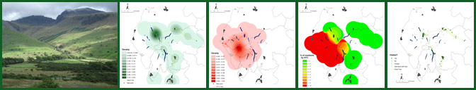
 The next GIS map has been created following the application of the ten-stage classification system to Gray's 'Journal'; and the size of the coloured spots relates to the number of references Gray makes to particular locations within the Cumbrian landscape. To give an example, the large red spot at the southern end of Derwentwater signifies Gray's detailed account of the 'turbulent Chaos' (p. 1080) in the vale of Borrowdale. This 'mood mapping', then, visualises the way in which this enclosed space represents the emotionally-heightened centre of Gray's tour of the Lakes.
It would be illuminating to use this system of adjectival classification to map out a range of Picturesque texts and to explore what spatial patterns emerge in the textual documentation of region. Does the landscape encircling the village of Grange become an imaginative 'hot-spot' for the Picturesque tourist? By extension, do Picturesque writers find it difficult to transcend the intertextuality of this particular space? Alternatively, which writers, if any, offer a challenge to Gray's description of the 'towering crag[s]' and 'dreadful bulk' of the 'jaws of Borodale' (pp. 1079-80). Once again, these questions reinforce Franco Moretti's argument that perhaps the greatest strength of literary cartography lies in the mapping of significant numbers of geo-specific texts: a critical approach which Moretti labels as 'distant reading' ('Graphs, Maps, Trees', p. 1).
Gray's 'Journal': Mood Map
/Gray Mood Maps Small.GIF) |
However, this GIS also underlines a fundamental problem of this kind of literary mapping. According to this 'mood map', Thomas Gray articulates an 'unpleasant' or 'undesirable' experience of Penrith; but, in his 'Journal', Gray uses the word, 'dreary', to describe the view northwards from Beacon Hill, which itself is just to the north of the market-town: 'to the N: a great extent of black & dreary plains'. The 'unpleasantness', then, needs to be mapped on to the view from Penrith rather than the built environment itself.