Aims & Objectives
The overarching aims and objectives of the 'Mapping the Lakes' project can be separated into three main areas: the writer-specific; the geo-specific; and the broadly conceptual/theoretical. These areas of interest overlap and intersect; but the three categories help to illustrate the range of our (indivisible) concerns and preoccupations.
Structure of the Site: Base, Comparative & Exploratory Mappings
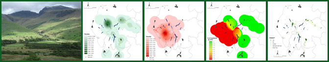
In developing a structure for this website, the aim is to construct a spatial narrative by inviting the user to move through a series of increasingly experimental and exploratory  cartographies. The writer-specific pages provide GIS mappings of the textual representations of the routes followed by both Gray and Coleridge as they progressed through the Lake District landscape, offering different cartographical versions of this spatial 'data'. The comparative section seeks to move beyond these single-author cartographies by highlighting the potential of layered GIS maps: maps which document the representation of place across multiple texts. It is hoped that the construction of these comparative cartographies points the way towards the conception of the Lake District topography as a spatial intertext. In the third stage of the cartographical process, exploratory maps are presented to highlight the ways in which GIS technology might be used to map out more abstract, imaginative and emotional responses to landscape and environment. This section of the site moves towards the possibility of a qualitative literary GIS. Finally, the interactive section demonstrates the representational potentiality presented by the interactive, multi-layered digital technology of Google Earth: this fourth stage of the mapping process offers a virtual movement through the Cumbrian landscape and provides a fluid space in which maps and texts can be brought together.
Methodology
The core aim of this pilot project is to test whether GIS technology has the potential to open up new spatial thinking about the geo-specific literature of place and space.  At the same time, the project is also an experimentation in interdisciplinary methodology: the possibilities and problems associated with the technological process are considered to be as significant as the critical and/or theoretical outcomes.
The first stage of the project involves the digitisation of the two primary texts. In addition, these two texts are 'tagged': that is to say, a system is developed for highlighting the use of place-names in both accounts of Lake District tours. A distinction also has to be made between those locations which the writers claim to have visited and those sites to which the writers refer but do not necessarily visit. These place-names are transferred into an Access database; and, then, geographical co-ordinates are manually attributed to each location through the use of EDINA's Digimap Gazetteer. This database is used as the basis for the creation of the GIS maps.
In 'Radiant Textuality: Literature After the World Wide Web', the textual critic, Jerome McGann, explores the construction of the online Rossetti Archive. McGann argues that there is a tendency for humanities scholars to use digital technology as a method of 'sorting, accessing, and disseminating large bodies of material': a methodology which leads to the marginalisation of 'questions about interpretation and self-aware reflection' (p. xii). McGann offers an alternative research model, theorising the process of digitisation and articulating what he labels 'a praxis of theory': 'the process of imagining what you know, testing it, scaling it up, modifying it, and then reimagining it' (p. 88). The 'Mapping the Lakes' pilot project is underpinned by similar methodological principles: the movement from 'base' to 'exploratory' cartographies highlights the ambition to 'scale up . . . modify . . . and reimagine' what might be meant by a literary GIS.
Choice of Primary Texts
The Department of English & Creative Writing at Lancaster University has a long-standing interest in literary representations of the Lake District and is the home of the Wordsworth Centre for the Study of Poetry (currently co-directed by Dr Sally Bushell and Professor Simon Bainbridge). The 'Mapping the Lakes' pilot project corresponds with the Centre's research and pedagogical interests in the relationship between literature and landscape within a regional space famously described by Wordsworth as 'a sort of national property in which every man has a right and interest who has an eye to perceive and a heart to enjoy' ('Guide', p. 225).
The literary GIS pilot project also emerges out of David Cooper's doctoral thesis on the twentieth-century poetry of Norman Nicholson. In this study, David articulates a theory of spatial intertextuality to explore the imaginative possibilities and problems faced by post-Romantic  Cumbrian poets. In situating Nicholson's rewriting of place, he also maps out a brief spatial history of the Lake District. The concept of a literary GIS, then, is developed through examination of the way in which Nicholson presents the Cumbrian topography as a palimpsest: a landscape in which every rock, stone and tree appears to be documented in multiple literary texts.
As a result, the 'Mapping of the Lakes' project is informed by two interweaving concerns: the exploration of how digital technology can facilitate further thinking about the spatial history of the Lake District; and, simultaneously, the idea that the Lake District can be used as a space with which to test the potentiality of a literary GIS. Given the strictly-defined parameters of the pilot, the focus is on two texts.
But why choose Gray's account of his 1769 tour and Coleridge's 'circumcursion' of August 1802? These two textual accounts of geographical experience - by two canonical writers - offer contrasting configurations of space. Both texts play crucial roles in the spatial history of the Lake District but in very different ways. As other pages on the project website explain, Gray's 'Journal' is a key text in the emergence of the Picturesque movement during the second half of the eighteenth-century: it is a text which plays a crucial role in shaping the ways in which later writers, artists and tourists respond to the Cumbrian landscape. Gray's 'Journal' offers an outsider's documentation of moving through this environment of crags and becks, fells and tarns. In the words of Norman Nicholson in 'The Lakers', Gray's 'Journal' 'anticipate[s] more than one aspect of the later Picturesque' (p. 58): an aesthetic movement which is 'primarily an attempt to educate the eye to a new way of looking at the natural world' (p. 38). As Nicholson puts it, the Picturesque, by the late 1770s, is 'already becoming a planned pleasure, a Butlin Camp of the sensibilities, with all its possibilities tasted, tested, tried, recorded, and mapped out (p. 63).
If Gray's 'Journal' prefigures the Picturesque movement, then, Coleridge's account of his 1802 tour offers a self-conscious movement away from Picturesque principles. His nine-day walking excursion can be interpreted as an attempted assertion of his socio-spatial insiderness: Coleridge's movement through the Cumbrian topography appears to offer an alternative conceptualisation and configuration of region to that suggested by Gray's 'Journal'.
As a result, the choice of the two primary texts is predicated upon a critical assumption of spatial difference: an anticipation that the two textual accounts offer contrasting models of the region. Yet, at the same time, there are clear points of comparison and intersection. Gray's mode of environmental response may be described in Picturesque terms but, as Marshall Brown points out, his writing can also be situated within the cultural and imaginative contexts of 'pre-Romanticism'. To return to Nicholson in 'The Lakers', Gray's engagement with landscape regularly advanced 'far beyond the visual asetheticism of [William] Gilpin and foreshadowed the splendid understanding of Wordsworth' (p. 59); and it is significant that, according to Duncan Wu, Wordsworth first read, and admired, Gray's 'Journal' in 1789 (p. 70).
Alongside this, both accounts of place have similarly complex textual histories which, in turn, raise significant questions regarding the relationship between spatial experience and issues of textuality. The use of Gray's 'Journal' and Coleridge's account of his 1802 tour allows the 'Mapping the Lakes' pilot project to begin an exploration of the theoretical implications associated with the digitisation of geo-specific texts which frequently transcend generic and formal boundaries. By focusing on these two accounts of place it has become clear that notions of textuality and spatiality will remain inextricably entwined in the creation of any literary GIS.