Troubled Geographies:
A Spatial History of Religion
and Society in Ireland
|
|
Troubled Geographies:
|
|
| Full text available from Indiana University Press | |||||||||||||||||
|---|---|---|---|---|---|---|---|---|---|---|---|---|---|---|---|---|---|
11. Belfast through the Troubles: socioeconomic change, segregation, and violenceBelfast illustrates of much of the division and interdependence that has taken place in Ireland over the last two centuries. Its success as an industrial city did much to separate the north-east of Ulster from the rest of Ireland. That success had much to do with developing strong links with Britain but it also brought many Catholics to the city. This left Belfast with complex spatio-religious patterns which, as chapter 10 identified, resulted in the city being the focus of much of the violence during the Troubles. Over the same period, as described in chapter 9, Belfast went through a period of rapid de-industrialization. This chapter firstly examines the evolving religious geography of the city and related developments in residential segregation. Secondly, it considers how Belfast has changed socially and economically over the thirty-year period between 1971 and 2001. Thirdly it looks at the patterns of violence within the city. Finally, the chapter draws these themes together to show how changing spatio-religious patterns and levels of residential segregation are related to wider socio-economic trends, thereby trying to set Belfast's experience within the broader context of urban change as observed in other societies. 
Fig 11.1: The Belfast Urban Area. Unshaded grid squares have populations of less than 25. Legend: Andersonstown (15); Ardoyne (3); Ballymurphy (7); Belfast Lough (2); Castlereagh (16); City Centre/City Hall (11); Donegall Pass (12); Falls (Lower) (9); Falls (Upper) (8); Lisburn (17); Lower Newtownards Road (14); New Lodge (5); Newtownabbey (1); Oldpark (4); Sandy Row (10); Shankill (6); Short Strand (13). The chapter uses 100m grid squares to provide demographic data for 1971 to 2001 for the Belfast Urban Area (BUA). The Belfast Urban Area, and its constituent parts, are shown in figure 11.1. Religious and residential segregation: The 'exceptional city'
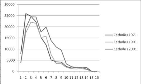
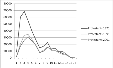
Fig 11.2: Belfast's religious geographies, (a) 1971 and (b) 2001. As figure 11.2 shows, by 2001 Belfast was more Catholic and more segregated than it was in 1971, however, the paths by which this happened are complex and set against and overall decline in population with a proportionate increase of Catholics. Fig 11.3: Population change in Belfast, 1971-2001 for (a) total population, (b) Catholics and (c) Protestants. Figure 11.3 maps these changes in more detail. Overall, as 11.3a shows, there has been a pattern of population loss throughout the Belfast Urban Area, particularly in the inner city. Figure 11.3b indicates that while numbers of Catholics fell in the inner city they grew along axes to the south-east and north of the city centre. Figure 11.3c shows that the Protestant decline was far more widespread. Neighborhoods such as the Lower Newtonards Road to the east of the city, the Shankill to the west, and Donegal Pass and Sandy Row south of the city centre were densely-populated working class areas associated with Belfast's heavy industries that saw high population falls over the period. Areas that saw Protestant growth were to the outer fringes of the Urban Area, indeed many Protestants left Belfast altogether for nearby towns like Ballyclare, Comber and Newtonards. Fig 11.4: Population by distance from City Hall among (a) Catholics and (b) Protestants. Distances are in kilometers. Figure 11.4 illustrates this further by the showing the populations of Catholics and Protestants by distance from the city centre. The Catholic population did not change much from 1971 to 2001, while the Protestant population between 2 and 6kms from the city centre fell sharply between 1971 and 1991 and then stabilised. These changes have thus made areas near the city centre proportionately more Catholic, while the Protestant population has become increasingly suburbanised. Industrial decline: typicality of other dimensions of changeBelfast's nineteenth century industrial based makes its experience in the twentieth century similar to other industrial cities in the UK and elsewhere in that it has had to face up to a loss of its traditional industries and other long-term socio-economic trends. Fig 11.5: Socially rented housing in Belfast in (a) 1971 and (b) 2001. Figure 11.5 shows that the distribution of socially rented housing has changed dramatically since 1971. At this time there were large numbers of estates where almost every house was socially rented. By 2001 overall rates of socially rented housing had declined dramatically in the face of 'right to buy' legislation but it remains prevalent in inner city and western areas. Fig 11.6: Employment as a percentage of the economically active population in Belfast in (a) 1971 and (b) 2001. Figure 11.6 shows how the distribution of unemployment, indicated by low levels of employment, has become more prevalent in inner city areas and parts of west Belfast over the three decades since 1971. Fig 11.7: Households lacking a car in Belfast in (a) 1971 and (b) 2001. Figure 11.7 shows households who did not own a car in 1971 and in 2001. Again there is a clear pattern of a decline in this indicator of deprivation, and again the higher rates remain concentrated in inner city and western areas.
Fig 11.8: Average household size in Belfast in (a) 1971 and (b) 2001. Finally, figure 11.8 illustrates how the average size of households has got smaller through time in Belfast with, by 2001, most of the urban area having smaller average households than in 1971. This is a common trend in other European and North American societies as more people live on their own in old age after separation or the death of a spouse and younger people delay forming two or more person households. These are all typical of the processes of de-industrialisation and counterurbanisation that are typical of the restructuring that could just as easily apply to Manchester, Sheffield or Detroit. Contemporary Belfast, in comparison to 1971, could be plausibly described now as a post-industrial or post-Fordist city. Changes in religious geographies and segregation need to be understood in the context of these macro-level trends. A conflict within a conflict: Violence in BelfastChapter 10 used the Sutton database of deaths to describe patterns of violence during the Troubles. It identified that the Troubles consisted of a number of separate but related conflicts, particularly one in which republican paramilitaries killed the security forces and vice versa with both also killing civilians, and a second in which loyalists primarily killed Catholic civilians. It also identified that patterns of violence had clear geographies that were determined, in part, by the underlying demographic and socio-economic geographies. This section analyses patterns of violent death in Belfast during the Troubles in more detail.
Fig 11.9: Density smoothed Troubles-related deaths in the BUA. Source: Peace lines downloaded from Northern Ireland Statistics and Research Office website. The Sutton database records 1,633 Troubles-related deaths in the BUA, slightly under half of all of the deaths recorded during the Troubles. A density smoothed map of these deaths is shown in figure 11.9 which also shows the locations of Belfast's main peace lines. The map shows that while many of the populated parts of the BUA were affected by violence to one extent of another, most violent deaths were concentrated in a relatively small area in the city center and west and north of it. These can be further sub-divided into seven main clusters: the City Center; the Lower Falls, west of the city center; west again is double cluster that consists of the Upper Falls and Ballymurphy; north of the Lower Falls, there is a cluster in the Shankill; north and west of this there is another double cluster that includes the Ardoyne and Oldpark; east of this is a cluster in New Lodge directly to the north of the city center; and finally, east of the city center is the Lower Newtownards Road cluster that lies in and around the Short Strand. The definitions and extents of these clusters is, to a certain extent, arbitrary but they nevertheless provide a useful framework to explore patterns of violence. These seven main clusters provide a useful framework for further analyzing patterns of violence in Belfast, as described in the book. Interpreting religious change and segregationThe Troubles led to large-scale population moves in Belfast. Those in the late 1960s are outside the data that we have available for this analysis, however these continued to occur in the early 1970s and as a result of ongoing lower-level violence and intimidation in the 1980s and 1990s. These do not tell the full story of Belfast, however, as it was also affected by the more usual processes described above. Fig 11.10: Population change 1971-2001 by population in 1971 for each 100m grid cell. Note that cells with a population of less than 25 have been suppressed. Figure 11.10 presents a further analysis of population change over the period which shows that cells that were densely populated in 1971 were the ones that showed the largest population losses over the next three decades. Areas that were in the top ten percent for population loss had a mean population of over 200 people per 100sq. m. cell while those in the top ten percent of growth had mean populations of around seven people per cell. Areas with high rates of loss also tended to have higher rates of socially rented housing and non-car ownership. In 2001 areas that gained population tended to have higher employment levels, more people per household and higher rates of owner-occupation. In short, population loss occurred in areas of social deprivation near the city centre as might be expected from other cities. Fig 11.11: Areas that were unpopulated in 1971 and more than 60% Catholic in 2001. This analysis, however, ignores the different religions. Protestants seem to have moved to the urban periphery while areas of Catholic increase were more spatially concentrated, and in particular, areas that were already Catholic became more Catholic. Figure 11.11 shows cells than were unpopulated in 1971 and more than sixty percent Catholic in 2001, in other words, where new housing has been built and occupied by Catholics. Most of this is in west Belfast where large housing estates were built in the 1970s and 1980s although there is some evidence of growth in the north-west and south-east of the city. It is possible to say with some certainty that at least some of the changes seen in Belfast have been the direct result of fear, violence and conflict, but it is equally possible to make a judgment that more normal forces have influenced the population of Belfast as they have in many other cities. Complicating this further, Catholics and Protestants as groups tended to be different in their socio-economic characteristics - particularly so in the 1970s, although less so in 2001 -and, in 1971, they already tended to live separately in segregated places. The same social and economic forces acting upon the two groups may therefore have led to different geographical and demographic outcomes without recourse to the Troubles - unequal starting points will normally create unequal results. ConclusionBelfast in 2001 was more Catholic, more segregated, older and less densely populated with fewer residents than it was in 1971. In some ways it was also more affluent with more owner-occupation and more households with a car. Employment rates, by contrast, had fallen, particularly in the inner city. It might therefore be thought to have become more polarised – an unsurprising finding given the evidence for growing inequalities both in the UK and Ireland. The processes that had brought the city to this point were, to some degree, like those experienced elsewhere in Europe and North America – Belfast, was far from the only city that had seen its manufacturing base decline. The most dramatic changes were seen between the censuses of 1971 and 1991 and, although it is impossible to date them with precision, it is known that the 1970s saw large-scale economic and demographic changes in general and it is tempting to assume the same timing in the case of Belfast. It is difficult to be certain about the processes and the motivations that underlay these developments however uncertainty is to be expected given the complexity and range of changes. Without doubt, sectarian factors such as the violence and fear associated with the Troubles were important, however, placing these forces in the wider context of urban change indicates that other influences worked upon Belfast, and it is also important to understand these. |
|||||||||||||||||
|
|
|
|
|
©Ian Gregory & Niall Cunningham, 2013