Underbarrow and Environs: Early Maps
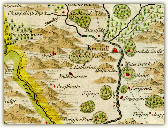
1. Robert Morden detail from Westmorland (1695)
2. John Cary detail of ‘Environs of the Lakes’ from Cary's New Itinerary (1784)
Kendal to from the Westmorland map by Robert Morden
(London: Morden, 1695).
Underbarrow and Environs: Early Maps
1. Robert Morden detail from Westmorland (1695)
2. John Cary detail of ‘Environs of the Lakes’ from Cary's New Itinerary (1784)
Kendal to from the Westmorland map by Robert Morden
(London: Morden, 1695).
Image © Meg Twycross
Morden’s county maps are the first to show roads. These are however based on Ogilby’s itineraries, so only the main trunk roads appear, and they occasionally fit uneasily into the landscape. Here the main London to Carlisle road appears, though Morden appears to have two versions of where it might run south of Kendal, as does the Kendal/Cockermouth road as recorded by Ogilby. The road to Underbarrow, though it existed, was not a major route, and so is not shown. The hills are occasionally a bit random.
Detail: Roads from Kendal westwards, from the map by John Cary (1784)
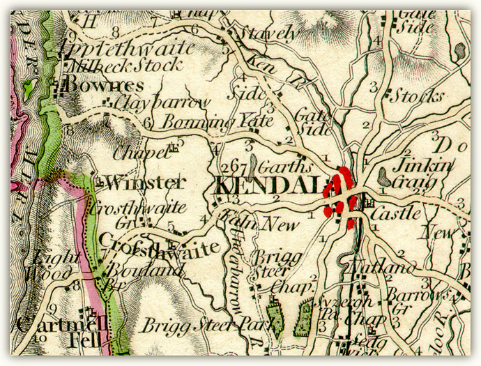
John Cary: detail of ‘Environs of the Lakes’ from Cary's New Itinerary (London: G. and J. Cary, 1784)
Image © Meg Twycross
Cary produced the first comprehensively detailed road maps of Britain, and his accuracy as a surveyor and engraver led to the commission from the Postmaster General in 1794 to survey all the roads of Britain. He also produced some of the earliest Ordnance Survey maps.
This map shows both major and minor roads, most of which are recognisable today. Cary also indicates the distances in miles along the main roads out of Kendal. The Underbarrow road was in fact the main route from Kendal to Ulverston, though it ‘was in its ancient state, “a mere track, from five to six feet wide, as may yet be seen in many places, particularly below the Underbarrow toll-gate ... Improved as the road was, it still followed the old track first marked out by the pack horses; passing over two mountains, where there were long and steep declivities — Underbarrow Scaur, and Staveley Brow, near to Fell-foot ... The old and most direct road, thro' Crosthwaite, is now almost deserted; in fact, grass grows upon it on the summit of Cartmel-fell.’1 Underbarrow is not mentioned on this map: instead, ‘Faln New’ three miles out of Kendal on the Underbarrow road is in fact ‘Fallen Yew’, the home of the Hubbersty family in the 17th century, at a significant fork in the road.
1. Quoted from William Pearson (1780-1856) Papers, Letters and Journals of William Pearson edited [with a memoir] by his widow [Ann Pearson] (London: Emily Faithfull, 1863), by 'Records of Kendale: The main roads' from Records relating to the Barony of Kendale: volume 3 edited William Farrer & John F. Curwen (1926), 1-20. Accessed from British History Online: http://www.british-history.ac.uk/report.aspx?compid=49337 Return