Preston Patrick to Kendal
Kendal was in the main route north from Lancaster to Carlisle, and a hub for the routes east to the Yorkshire Dales and beyond, and west to Cockermouth, and the Furness peninsula. The only ones shown on the near-contemporary road maps by John Ogilby (1675) are the Lancaster-Carlisle route and the Kendal-Cockermouth route.
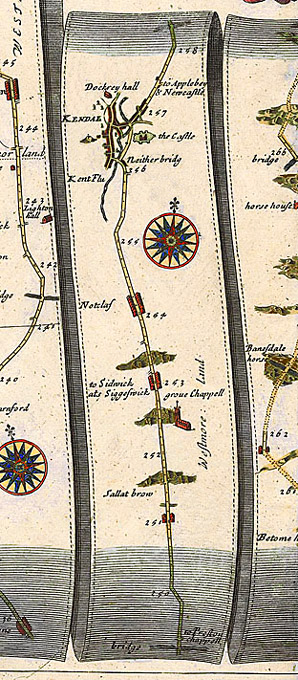
The 17th-century route from Lancaster follows the line of the present A4 till Carnforth, when it goes across via Borwick to Burton in Kendal, past between Holme village and the Holme Estate on the east, and then by Farleton and over the Peasey Beck at Crooklands by Peasey Bridge. After that it appears to have veered to the west (though Ogilby shows only a small dog's leg), and gone past Sedgewick and through Natland [Notclaf], entering Kendal by the Nether Bridge. It seems logical that Fox should have gone this way from Preston Patrick to Kendal.
The countryside is now so cut up with the canal, the railway, and the motorway that it is difficult to trace in places. It is now a very minor road.