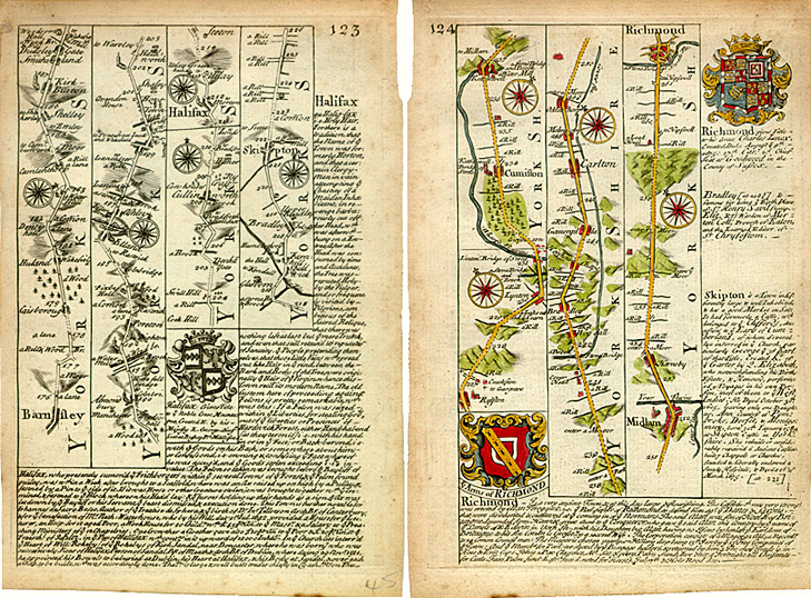
Seventeenth-century route from Skipton to Middleham in Wensleydale
John Owen and Emmanuel Bowen Britannia Depicta or Ogilby Improved (1725),
pages 123–4:
The route from Barnsley to Richmond
Image © Meg Twycross 2008
Maps based very closely on Ogilby's 1675 Britannia: the only alterations are a slight rearrangement of the placing of the captions, and the omission of the words ‘a Vill’ alongside towns and villages. Skipton is in the last column of page 123.
The maps are much reduced (these cropped pages 137mm wide by 220mm high) and accompanied by descriptions of places of interest and the nobility and gentry which whom they are associated. It is worth bringing up the enlarged version and moving the screen to sit side by side with the Google Maps version in the Dales Routes page. When you enlarge this the names on the Owen-Bowen version appear.
The route from Skipton (see orange route in Google Maps in the Dales Routes page) follows the modern B6265 from Skipton through Rylstone to Grassington; then up Wharfedale by the road on the other side of the river from the modern B616 to Kettlewell. Here it branches off sharply to the right to Coverdale towards Middleham and eventually Richmond. If Fox followed this route, he could have continued up Wharfedale to Langstrothdale and Scar House (yellow route) where he stayed with and convinced James Tennant and his family, and from thence over the tops (turquoise route) to Raydale and Semerwater, and on to Bainbridge and Askrigg, as suggested by David and Anthea Boulton. From thence he could have followed the old Roman Road (purple route) from Bainbridge to Gearstones, and on to Dentdale. But the chronology of his journey, and the route he followed are uncertain.
Close window to return.