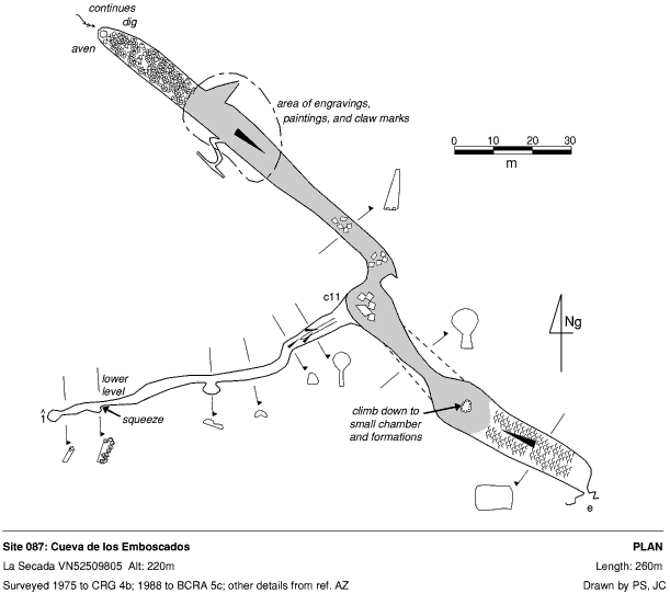
087 Cueva de los Emboscados
La Secada VN52509805 Alt. 220m Length 260m
Updated 5th September 1998; 16th September 2000
The entrance, gated in 1998, is at the head of a steep wooded slope, under a rock shelter. Goats were kept out of the cave by rocks which can be removed to reveal a small draughting hole. A short crawl enlarges and descends, past formations, into a fine 12m wide passage. The calcite slope levels out at a pit in the floor and then zig-zags to a gentle ascent to a draughting boulder choke. This has been dug through for about 8m in some major excavations. Part way along it is possible to see up into "space". The pit has a tight passage in its base and a tight squeeze which opens out into a small chamber. A number of small passages all choke but there are some nice formations.
Up on the left at the dogleg a climb of about 8m enters an extra 66m of passage. Description...........?
The cave may also have been an ancient outlet for the Matienzo water and the choke at the end could repay further digging.
With its south facing entrance, above the river, it is likely that Emboscados was used as a habitation.
L. Mills found a rounded stone or iron nodule, which had been hammered at both ends, in the central part of the cave in 1975. In 1979 several prehistoric engravings were located in the second passage. These include several deer, goats and other lines, not interpreted. A curving line of red paint crosses over the back of the first deer. Also in 1979, a flint was found in the entrance. Some shells and prehistoric pottery, possibly Bronze Age were found inside the entrance by C.A.E.A.P. in February 1991.
See also Iberia before the Iberians (Strauss Lawrence Guy, 1992, p133 and 176).
Possible gating to protect the engravings and artefacts is mentioned in León J and Smith P, 1993.
Link to page at the University of Cantabria.
References: Fernández Gutiérrez et al, 1966 (survey);
anon., 1974a; Cox G, 1973; Kendal Caving Club and Manchester University
Speleological Society, 1975 (survey); anon., 1976 (logbook); Addis F et al,
1979; Manchester University Speleological Society, 1982; anon., 1980a (logbook);
Corrin J et al, 1981b; Corrin J, 1980; Mills L D J and Waltham A C, 1981
(survey); Smith P, 1981c ; Smith P, 1981a; Corrin J S and Smith P, 1981;
anon., 1982 (logbook); Corrin J, 1983c; anon., 1983b (logbook); anon., 1986
(logbook) (survey); Smith P, 1986a (survey); anon., 1988 (logbook); Cawthorne
B and Neill A, 1990; Balbin R et al, 1986; material in file; Cawthorne Bob
et al, 1988; anon., 1989 (logbook); Neill A et al, 1989; Smith P, ?; anon.,
1991 (logbook); anon., 1992a (Easter logbook); anon., 1993b (logbook); Neill
Alasdair and Jackson Keith, 1993; Muñoz E and Bermejo A, 1987; León
J and Smith P, 1993; anon., 1995a (Easter logbook); anon., 1995b (Whit logbook);
anon., 1995c (logbook); Smith P, 1995 (survey)
Entrance picture : position from the
road entrance shelter
Underground picture(s): surveying past
formations surveying in passage
looking back down from end choke
Detailed Survey : 1:1000
Line Survey :
On area survey :
Survex file :