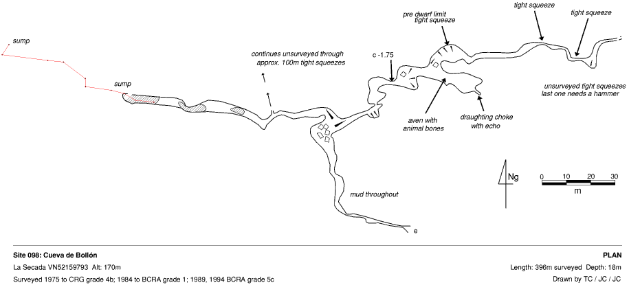
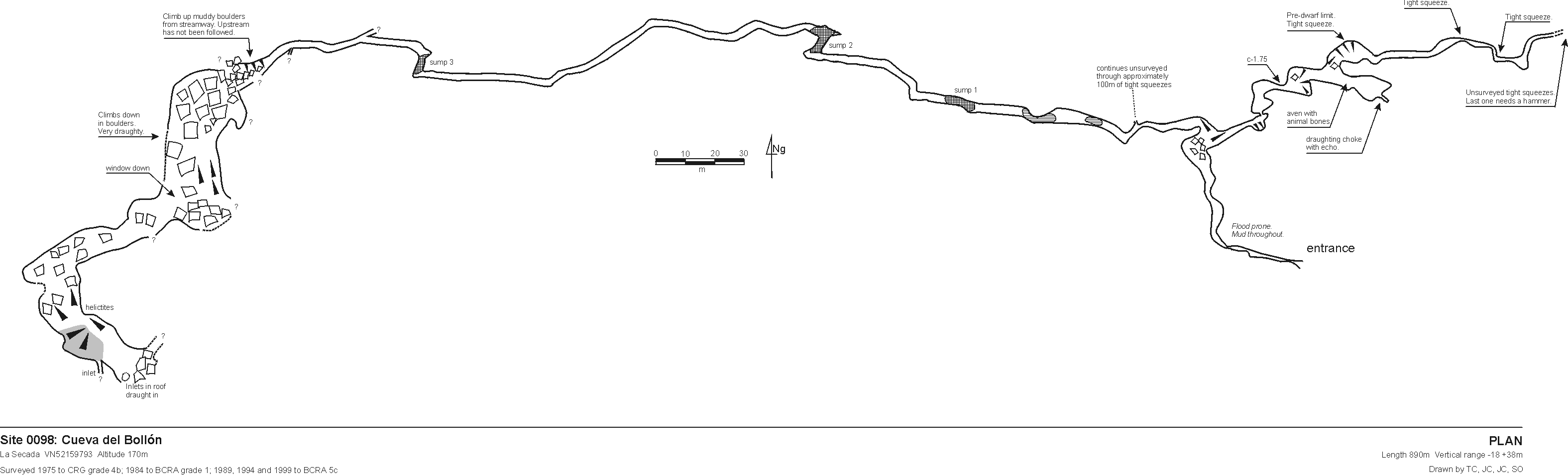
098 Cueva del Bollón (Cueva de Volvo)
La Secada VN52159793 Alt. 170m Length 890m Vertical range
-18m +38m
Updated 17th December 1999; 14th May 2000; 21st January 2001
The cave acts as a resurgence and floods completely in very wet weather.
A descending rift leads to a mixture of walking and muddy crawling for 70m until a chamber is reached. By sliding down to the left, deepening water leads to a 3m sump which is not free-divable. This was passed in the summer of 1994 to another stretch of passage ending at a promising sump. At the end of summer 1995 expedition, this had dried out somewhat to become muddy wriggle to a steep, muddy climb out. Approximately 120m of westerly- trending, sand and mud-floored passage, ends at sump 3. Some 40m from sump 2, a passage leads off to the north for 30m ending at a boulder-filled pool.
Just before sump one, on the right hand side, a nasty, wet, strongly draughting crawl was dug through to Passage of Slime and a muddy boulder choke. This is passed by a squeeze and climb up to high level. Around here are two climbs: the first is 20m in bad rock; the second needs a couple of bolts and is safer. The draught can be followed down to a large choked chamber with two avens. One goes to a chamber with two over tight passages. The second could not be protected due to bad rock. This area needs a return trip.
To the right of the chamber, a tight squeeze at floor level on the left of the passage leads to a succession of muddy chambers. One impassable crawl at floor level in this section has a very strong draught. Other minor extensions have been made (including a couple of avens - Phil Boardman - are these on the survey?)
The villagers claim that this cave connects with the sea, as on the occasions that it acts as a flood resurgence, it washes out quantities of sand and shells. The end of the eastern branch appears to lie only 70m away from the western extremities of the Western Series in Cueva de Carcavuezo (081).
In 1999 sump 3 was passed and all sumps were described as free divable with the summer water levels. Beyond sump 3, 40m of walking and stooping passage leads to the base of a steep boulder slope. There is a large amount of collapse debris and care should be taken. A short traverse around to the right at the top of the first slope leads to an eyehole 6m from the far wall where it is possible to climb down to a section of passage containing large, old stal which has fallen. Straight ahead is a blank wall but to the left is a second slope of about 30 degrees leading past a small bunch of helictites before emerging on a sandy plateau. The slope continues upwards beyond this where a Yorkshire pot-type inlet is seen on the right and other possible inlets are seen in the roof.
This area is beneath sites 1452 and 898 and draughts. There are many leads and crannies to examine throughout the cave including the streamway continuation beneath boulders before the climb up.
At Easter 2000, site 1452 was linked in via a 35m pitch to where it is possible to swing across to link with the slope. Heavy rain a couple of weeks before meant that the water levels were high at the base of the slope and it was impossible to investigate upstream.
References: Fernández Gutiérrez et al, 1966 (survey);
anon., 1974b (logbook); anon., 1974a; Cox G, 1973; anon., 1975b (logbook);
Kendal Caving Club and Manchester University Speleological Society, 1975
(survey); anon., 1980a (logbook); Corrin J S and Smith P, 1981; anon., 1984
(logbook); anon., 1985b (logbook); anon., 1987 (logbook); Corrin J and Knights
S, 1988 (survey); anon., 1988 (logbook); Davis J and Corrin J, 1989 (survey);
anon., 1989 (logbook); anon., 1993b (logbook); material in file; anon., 1994b
(logbook); Corrin J, 1994b (survey); anon., 1995c (logbook); Corrin Juan,
1995a; anon., 1999c (logbook); Corrin Juan, 2000; anon., 2000b (Easter logbook)
Entrance picture :
Underground picture(s):
Detailed Survey : 1:1000 (old)
1:1000 (new - 1999)
Line Survey :
On area survey :
Survex file :