Troubled Geographies:
A Spatial History of Religion
and Society in Ireland
|
|
Troubled Geographies:
|
|
| Full text available from Indiana University Press | ||||||||||||||||
|---|---|---|---|---|---|---|---|---|---|---|---|---|---|---|---|---|
7. Continuous Division, 1920s-1960sThe Boundary Commission of 1925 confirmed the territorial settlement of partition. Ireland would remain divided but ironically Northern Ireland and the Irish Free State had the same problem at the start of this period. The 1921 Treaty had created two states but it had not created two nations1. Religious geographies had determined the spatial extents of the two jurisdictions, but the choice for both north and south was whether to forge their own identities or to continue to be defined by the sectarianism of their geneses. The politics of populationFig 7.1: Percentage of the population at county level born in the northern six counties of Ireland and resident in the southern twenty-six counties, or vice-versa in (a) 1926 and (b) 1946/51. Figure 7.1 shows the distribution of people born in the other state to that in which they are living, e.g. people born in the Northern Ireland and living in the Republic and vice-versa. The map shows that there was consistently more people from the south living in Northern Ireland than the opposite way round. Over time the number of people from the south living in the north declines.
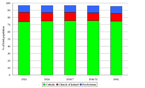
Figure 7.2 shows how population density changed over the period from 1936/7 to 1961. As established in the previous chapter, even in 1926 much of the island was sparsely populated however over time many areas, especially in the west and centre lose population over this period. By 1961 a substantial part of the island had a density of less than 0.1 persons per acre. Northern Ireland seems far less prone to this with the exception of parts of Fermanagh. At the same time, Belfast and Dublin show some evidence of growth with limited spread inland in Lisburn and Rathdown respectively, however substantial suburbanisation had not occurred by 1961. Fig 7.3: Percentage population change at rural and urban district level between 1926 and 1961. Figure 7.3 confirms these trends with the largest declines occurring in the north-west of the Republic, stretching along the border to the Irish Sea. Losses in Northern Ireland were not of the same magnitude as those in the south. The urban centres and their hinterlands show stability and growth, notably around Belfast and Dublin, but also in Cork, Derry, Galway, and to a lesser extent Limerick and Waterford. This poses the question of why the Free State and then the Republic was unable to deal with the population crisis that it faced over this period. Economics, industrialisation and identityFig 7.4: Percentage of the population employed in agriculture at county level in (a) 1926, (b) 1936 (Free State only) and (c) 1946/51. Figure 7.4 shows how important agriculture remained to the economy, particularly in the west of the Republic. It is also clear that partition had further skewed the fiscal profiles of the two newly created states. Fig 7.5: Percentage of the population employed in manufacturing at county level in (a) 1926, (b) 1936 (Free State only) and (c) 1946/51. Figure 7.5 illustrates this point further. Manufacturing employment over the island is overwhelmingly concentrated in Northern Ireland, however, over time the Free State's employment in manufacturing did grow from 110,558 in 1931 to 166,513 in 1938 with a 40 percent increase in output from 1931 to 19362. Fig 7.6: Percentage of the male population economically inactive at county level in (a) 1926, (b) 1936 (Free State only) and (c) 1946/51. Figure 7.6, showing economic inactivity among males, would seem to further emphasise this split. There are, however, issues that make this pattern less clear cut. The depression of the 1930s hit Northern Ireland harder than any other region of the UK. In 1938 29.5% of insured industrial workers were unemployed compared to 23.8% in Wales, the next hardest hit region. It is also important to stress the the final map in each of these series is for 1946 south of the border, when the European economy was still only just emerging from the War, while for Northern Ireland it was for 1951 by which time post-War rebuilding had begun. It seems, however, as if the War revitalized Northern Ireland's heavy industries while further developing agriculture in the Republic to compensate for shortages caused by the war. A new period of economic stagnation thus ensued in the Republic. In the immediate post-war period 500 ,000 people emigrated3, and the economic divide on the island is starkly illustrated by the contrasting patterns of economic inactivity north and south of the border in the post-war period. Religion and state buildingFig 7.7: The three major religions’ share of the total population of the island of Ireland between 1911 and 1961. The graph above shows that there was a remarkable consistency in the balance between the three main religions in Ireland from before partition to 1961. Partition did not solve the problems of Ireland's troubled religious geographies, but it did change them by creating two different minority issues in the Free State and in Northern Ireland. How they responded would define both states in the mid-twentieth century.
As figure 7.8 shows, partition created an overwhelmingly Catholic population south of the border, by 1926 only 7.6 percent of the Irish Free State's populace was Protestant. This minority was geographically scattered and economically stratified, playing a disproportionately powerful role in Irish business, commerce and the professions. They accounted for 28 percent of farmers with over 200 acres, 38 percent of lawyers and 53 percent of bank officials4. Despite this, the Protestant population continued to decline in areas where they had traditionally been significant minorities including west Cork, the Pale and parts of the midlands.
Figure 7.9 breaks this pattern down by showing the distribution of Presbyterians. This group never made up a significant proportion of the three southern provinces. Instead they were heavily concentrated in Ulster where concentrations of them in counties south of the border remained as significant minorities in the time after partition.
By contrast, as figure 7.10 shows, the Church of Ireland was scattered across the southern provinces and this group shows decline from 1926 to 1951 but this is to nothing like the extent shown over the partition period.
In Northern Ireland the picture was somewhat different. Partition gave a Protestant majority of 2:1 but, as the maps above show, this left a large Catholic minority population. In substantial parts of the province west of Lough Neagh and the River Bann, in south Armagh and south Down, in the Glens of Antrim, and in working-class parts of Belfast, Catholics actually formed a majority. Compounding this, and related to it, the vast majority of these Catholics did not recognise the very legitimacy of the state, in stark contrast to south of the border where the Protestant minority largely accepted the new dispensation. The Northern Ireland government's response to this was to further marginalise the Catholic population politically through the abolition of proportional representation and the gerrymandering of constituency boundaries. ConclusionsIn the period between the 1920s and 1950s the divisions which partition had formalised in Ireland became even more entrenched. This occurred not only as a result of policy decisions but indirectly by the creation of two, competing political cultures in which the necessity for accommodation and toleration had been removed by the religio-territorial settlement of 1921 and confirmed in the Boundary Commission report of 1925 which created a overwhelmingly Catholic south and a Protestant dominated north. The maps below show that over the longer period from 1911 to 1961 the process of religious realignment had continued with the Protestant populations in areas south of the border continuing to fall. This was not balanced by a discernable decline in the Catholic proportions north of the border, on the contrary over this period the Catholic population in the greater Belfast area, specifically in a transect west of the city, increased considerably. Fig 7.14: Percentage point change between 1911 and 1961 in the populations of (a) Catholics, (b) Church of Ireland and (c) Presbyterians. In 1948 the then Taoiseach John A. Costello surprised not only Britain and Northern Ireland but the population of the south as well when he declared it was to become a Republic. What was most telling about this episode was that it became emblematic of how far the two parts of the island had strayed from political realities, even since partition. Costello had earlier spoken of the hopes of uniting Ireland while the declaration only made this less likely. The northern Prime Minister promptly called an election which acted as a referendum to firmly endorse the territorial settlement. Division was not only an external theme but one that defined relations between different religious groups within both states in this period. The religious homogeneity which partition imposed on the Irish Free State became a wider feature of its political and social development, whereas the relative parlousness of the northern Protestant position fostered insecurity and obduracy. In the coming decades both states would be forced to confront the legacy of the resentments which had piled up in this period. 1. B. Anderson, Imagined Communities, 2nd Edn.,(London: Verso, 2006), p.7. 2. T. Brown, Ireland: A Social and Cultural History (London: Fontana Press, 1981), p.144. 3. J.J. Lee, Ireland 1912 – 1985: Politics and Society (Cambridge: Cambridge University Press, 1989), p. 384. 4. R.F. Foster, Modern Ireland 1600 – 1972 (Harmondsworth: Penguin, 1989), p. 534 |
||||||||||||||||
|
|
|
|
|
©Ian Gregory & Niall Cunningham, 2013