(PIT)
Calibrating and Evaluating the Phosphorus Indicators Tool (PIT)
Cost: £188k
Duration: 2001-2005
Project Overview
People and Institutions
Results and Applications
Publications
Latest Updates
Results and Applications
The PIT model consists of a number of layers of coefficients:
- Layer 1:
Estimates the amount of available phosphorus from manure and fertiliser application based on land use and soil type.
- Layer 2:
Estimates the amount of phosphorus that can be transferred based on the available phosphorus from Layer 1
- Layer 3:
Estimates of delivery of phosphorus to water based on the outputs from Layer 2.
A risk index has been created using the estimates from Layer 3 and an index of connectivity between the land and the surface water.
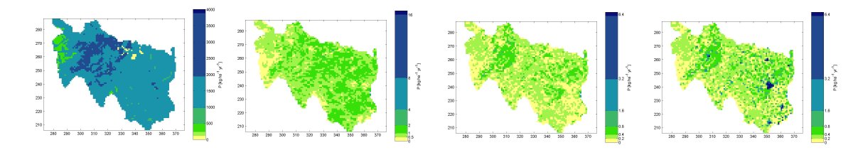
This framework has been applied at a number of scales from individual catchments through the EA River Basin Districts from the Water Framework Directive to the national scale. The results from these model runs show a strong similarity to the results from other phosphorus export tools. Ten data-rich catchments were evaluated as part of this project. The PIT model predictions showed P delivery estimates similar to the observed data for the Windermere, Lambourn, Avon, Windrush, Slapton and the Wye catchments. For some of the catchments: Taw, Enborne, Esthwaite, the PIT under-predicted the observed results. These catchments have relatively high observed P delivery. It is possible that the screening tool struggles to reproduce these high observations due to the lack of suitable spatial resolution data within the tool. For the Avon and Wye catchments that were studied in detail in the Psychic project, there was a good fit between both the spatial distribution of P delivery within the catchments, and in terms of the overall magnitude of predicted P loss.
A simplified version of the PIT model has been used as
part of the River Basin Characterisation assessment under Article 5 of the
Water Framework Directive, to identify the pressures on surface waters from
diffuse P sources. The PIT model has also been recommended for inclusion in the Environment Agencies mode toolkit: 'Environmental Effects of Agriculture and Land Use: sub project 1 - model toolbox selection'