|
Crossing the Sands ‘& wee ridd uppe ye sands where neuer noe man before ridde (not knoweinge ye way nor ye daunger of ye sands) a very dangerous place’.
North-West of Lancaster the old county was severed by Morecambe Bay. What is now Cumbria was known as Lancashire North of the Sands. Camden describes it as he saw it in 1582 from the battlements of Lancaster Castle: Whiles I looked around about from the top of the said castle hil to see the mouth of Lone, that issueth it selfe into the sea a little lower, Fornesse the other part of this shire appeered in sight, which the sea hath after a sort violently rent apart from the rest. For whenas the shore did from hence shoote out a maine way into the West, the Ocean, as it were much displeased and angry hereat, obstinately ceased not to slash and mangle it, nay, which is more, hath with his fell flowing at boisterous tides devoured the shore, and thereby maketh three wide creekes or bayes, namely, Kent-sand, at which the river Ken powreth it selfe forth, Leven-sand and Dudden-sand ... All this part unlesse it be hard by the sea side, mounteth up aloft with high topped hilles and huge fels standing thicke together (which they terme Forness-fells).1 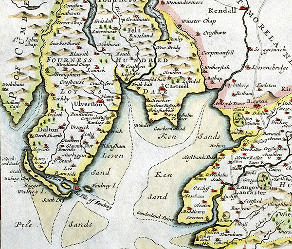 Robert Morden Morecambe Bay: details of ‘Lancashire’ and ‘Cumberland’ joined (illustrations to 1695 edition of Camden’s Britannia) The terrain makes travel difficult, even today. Most obviously, you have to skirt the Bay to get to Barrow-in-Furness from Lancaster, a distance of 17 miles as the crow flies, but 48 miles by road. Swarthmoor is 16 as the crow flies, but 39 miles by road. Today the shortest way between Lancaster and the Lake District Peninsulas is by rail via the railway bridge at Arnside (opened 1 August 1858). Drivers must go about 5 miles further north up the A6 to join the A590 at Levens Bridge (20 miles from Lancaster). |
||||||||||||
 Cary 1794 sheet 58, detail. |
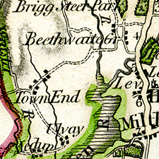
However, this road only appears on maps as a viable route in the mid-1820s at the earliest, after the 1818 Act of Parliament which provided for the building of a turnpike from ‘from Greenodd in Ulverston parish to Levens Bridge in Heversham parish’. There was a track which went across the bottom of the Lyth valley, marked in some earlier maps with a dotted line (see left), but it was impassible and even submerged in wet weather.2 The Lyth Valley itself was a moss (marsh); after drainage in the 18th century it was used for harvesting peat. Even nowadays when it is famous for its damson orchards, the pumps have to keep running continuously. The turnpike was bedded on bundles of juniper cut from Whitbarrow Fell. It was surveyed to be much straighter than the old road, and a new bridge over the river Gilpin was constructed at Gilpin Bridge.3 |
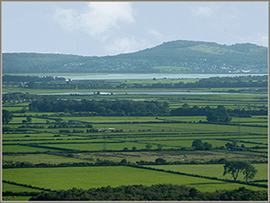
Looking down the Lyth Valley towards Arnside. |
||||||||||
|
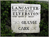
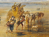
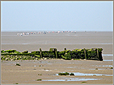
In the seventeenth century, there were two choices for travellers between the south coast of what is now Cumbria and Lancaster. They could go up to Kendal and then follow the ‘main’ road through Underbarrow, Crosthwaite, and round the top of Whitbarrow Scar onto Cartmel Fell, dropping south by minor tracks to get to Lindale and Cartmel itself, then round the head of the Leven at Colton to continue to Ulverston. This was the route Fox took on his first journey. It was tortuous, to sidestep the major outcrop of Whitbarrow, though it did not avoid some very steep slopes, and the road was not good: ‘the present mountainous track of road by land which beggars description’. (It should be remembered that these were largely packhorse roads.) Or they could cross the sands of Morecambe Bay, first across the Kent estuary to the Cartmel peninsula, and then the Leven to Furness. 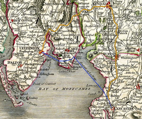 Cary 1794 larger detail from sheets 58 and 49. Road route in orange. Sands route in blue. The Quartermasters’ Map of 16444 shows Hest Bank Passage, ‘Cartlons’ (possibly a mistake for ‘Cartmel’, possibly for ‘Carter’s’ — the guides to the sands were called ‘carters’) Passage, and Conyside (Conishead) Passage, and this is repeated by Morden’s 1695 map (above).  Detail from Quartermasters Map 1644 The advantages of the Sands route are obvious. But it was potentially dangerous. The channels can change daily. There are quicksands. Above all, the tide comes in faster than a man can run. One or two people were drowned every year, even those most familiar with the route. One of its victims was Miles Hubbersty of Underbarrow: And Inasmuch as the outward bodys of good as well as evill Men are lieable [liable] to the like dangers & ends, The Lord, who is Infinit in Wisdome, permitted it to be that as the said Miles was rideing over The Sands wth severall in Company, he fell of his horse into the water, and allthough some in the Company did venture theire lives to save his, yet was then drowned; and allthough his end hapened thus, doubts not of his well being. And after, he was brought to the house of Joseph Sharp, of Quary fflat, and upon the [15th] day of ye [10th] month, 16[75], was bueryed in ffriends Burying ground, at Height, in Cartmell ffell, aged about [48] years. The most famous recent victims were the 23 Chinese illegal immigrants overrun by the tide while cockle-picking near Wharton in 2004.  The smiling and threatening face of the Sands: looking towards Whitbarrow from Arnside (tide out) 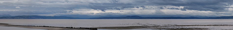 and from Hest Bank (tide in). This was taken a few days after the Bay Walk one below. Before the Dissolution of the Monasteries, the Leven crossing was looked after by Conishead Priory, and the Hest Bank crossing by Cartmel Priory. After the Dissolution, the priories were acquired by the Duchy of Lancaster. The Duchy appointed official Guides to the Sands, the first in 1538 by Letters Patent (the Duke of Lancaster is the monarch, and a Guide is known as ‘The Queen’s Guide to the Sands’). There is one for the Leven Sands and one for the Kent Sands. Both tend to be local fishermen, often shrimpers. The Kent Guide had an annual fee of ten marks (a mark was 13s 4d), and a tied house. He was often known as ‘the Carter’ — nowadays walkers are accompanied by a tractor. During this period, the Sands route was a main road, and coaches were introduced in the eighteenth century; since other routes became easier and safer, the Guide leads supervised Bay Walks for as many as 500 people at a time, often by the shorter route from Arnside: see the Guide over the Sands website for up-to-date information. The legendary Cedric Robinson MBE retired in 2019 at the age of 86, after 56 years of service, and has been succeeded by Michael Wilson of Flookburgh, also a shrimper. The Leven Sands Guide is Raymond Porter. The Guides are now selected by the Guide over the Sands Trust.
1. William Camden Britannia translated Philemon Holland (London: George Bishop & John Norton, 1610): online, both 1607 Latin text and 1610 English translation, at http://www.philological.bham.ac.uk/cambrit/, edited Dana F. Sutton. This passage at http://www.philological.bham.ac.uk/cambrit/durhameng.html#lancs1. Return 2. A major inconvenience for the inhabitants of Witherslack, who during the winter had to carry the corpses of their dead by the long route round the head of the valley to their parish church at Beetham 5 miles south of Levens. (At the time the road through Milnthorpe and Beetham, now the A6, was also in a moss and frequently impassible.) They were freed from this by the bequest of a local boy made good, John Barwick, Dean of St Paul’s, who died in 1664, leaving money for the building of a new village church and the consecration of a burial ground. The church was built in 1668/9, and displays the arms of Dean John and his brother Dr Peter Barwick, who was Physician in Ordinary to King Charles II. Return 3. Paul Hindle Roads and Tracks of the Lake District (Milnthorpe: Cicerone Press, 1998; reprint 2009) 172-4; For a detailed account, see J.L. Hobbs 'The turnpike roads of North Lonsdale' Transactions of the Cumberland & Westmorland Antiquarian & Archaeological Society 55
(1955) 250-292 and map. Online and downloadable at
https://doi.org/10.5284/1062596, Archaeology Data Service Library. For a detailed general survey, see Records relating to
the Barony of Kendale: volume 3 edited John F. Curwen (Kendal: Titus Wilson, 1926), online at
http://www.british-history.ac.uk/kendale-barony/vol3/pp1-20. 4. Online at British Museum website. Return |
||||||||||||