|
|
Road as shown by Ogilby: orange route. Scroll the map
down to follow Ogilby’s route back to Lancaster. |
|
Preston Patrick to Kendal
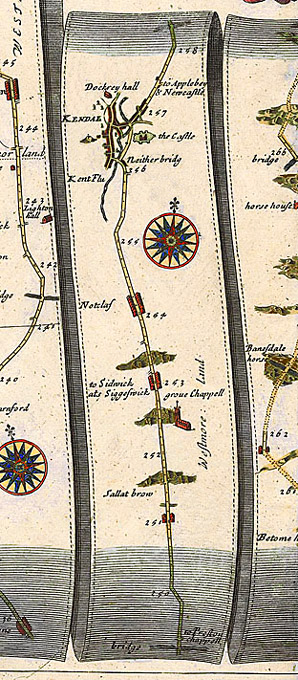
1. John Ogilby (1675)
2. Robert Morden (1695)
3. John Owen and Emanuel Bowen (1720)
Kendal was in the main route north from Lancaster to Carlisle, and a hub for the routes east to the Yorkshire Dales and beyond, and west to Cockermouth, and the Furness peninsula. There was also a network of lesser tracks and drove-roads. However, the near-contemporary road maps by John Ogilby (1675) only show the main post roads, Lancaster to Carlisle, and Kendal to Cockermouth.
John Ogilby (1675) compared with Google Map.
The 17th-century route from Lancaster follows the line of the present A6 till Carnforth,1 when it goes across via Borwick to just before Burton in Kendal at Heron Syke, on the border of Lancashire and Westmorland; 2 then on through Burton to the north, passing between Holme village and the Holme Estate, and then past Farleton and over the Peasey Beck (possibly at Crooklands by Peasey Bridge, but the lie of the road suggests more to the west). The direction of the road here was slightly changed after the Enclosures Act (1814). After that it appears to have veered slightly to the west (Ogilby shows only a small dog's leg) before Stainton, going up Sellet Brow, skirting Sedgewick and going through Natland [Notclaf], and entering Kendal by the Nether Bridge. It seems logical that Fox should have gone this way from Preston Patrick to Kendal. Celia Fiennes (1698) says that for the last ten miles to Kendal, ‘most of the way was in lanes when I was out of the stony hills, and then into inclosed lands’.
The current A65 from Kirby Lonsdale was not the main route north; it comes from Skipton, and was turnpiked in 1752.
|
|
Road as shown by Ogilby: orange route. Scroll the map
down to follow Ogilby’s route back to Lancaster. |
|
|
The thumbnails below lead to larger images of the road north from Preston Patrick to Kendal. Click on a thumbnail to activate. | |||

|

|

|

|

|

|

|

|

|

|

|

|
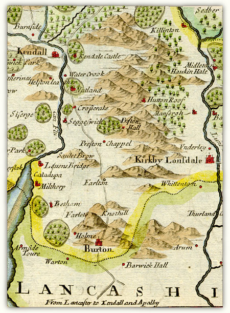
Robert Morden (1695): detail from Westmorland
Morden was the first to include some roads in his county maps, mostly from Ogilby. This shows where Ogilby’s route lies in the landscape. The projection is rather strange — Preston Patrick is shown as lying to the north of Sellet Brow, and Hutton Roof is placed way north of Kirby Lonsdale. Some of the hills round Burton in Kendal seem random: Farleton Fell has apparently replicated itself, and the main road goes round its back before returning to Crooklands. There appears to be an alternative route sketched in to the left of the main road: it is so faint it is hard to tell if it is meant to be a distinct road, or another suggestion for the same road.
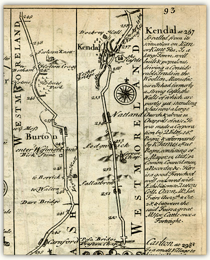
John Owen & Emanuel Bowen (1720): detail ‘Garstang to Kendal’ from Britannia Depicta or Ogilby Improved page 94
A travellers’ edition of Ogilby’s map, the maps reduced in size, tidied up and the spellings rectified. Descriptions of important towns (here Kendal) are included on the page.
Return to Kendal Topography index page or Close Window to return to text
1. The current A6 between Carnforth via Beetham, Milnthorpe, and Sizergh was not constructed (by Macadam) until 1822: before that the land was too marshy. There was however a 1759 turnpike from Kendal to the Dixies Inn at Sandside: Milnthorpe was Westmorland’s only port [Brian Paul Hindle Roads and Tracks of the Lake District (Milnthorpe: Cicerone, 1998 revised edition of 1984) 169]. Return
2. The road from Carnforth to Heron Syke (the border of Lancashire and Westmorland) was turnpiked in 1751, and from Heron Syke to Kendal and beyond in 1753 [Records relating to the Barony of Kendale: volume 3 edited John F. Curwen (1926) 1–20]. Return