

Geoscience Electronics
As part of the E-MIT research group, we undertake a theoretical and applied research in electronic engineering for geoscientific applications.
From our academic home at Lancaster University’s School of Engineering, we collaborate closely with scientists and engineers from Cambridge, Cardiff, London and abroad. Our focus is on developing new techniques and instrumentations for terrestrial subsurface monitoring and imaging across the frequency range from HF to microwaves. By doing so, we hope to realise the tools and algorithms needed to improve our knowledge of the fundamental processes that are occurring within some of the most dynamic (and fascinating) areas in the Earth’s system.
Key research
Accordion
-
Radioglaciology
Radar sounding of glacial ice was first reported around the 1950s. The technique of radio-echo sounding (RES) has since become an important tool for the study of ice sheets and glaciers. Our research focuses on the development of a class of portable, ground-based radar for year-long, millimetre-precision monitoring of the basal melt rate of Antarctic ice shelves and imaging of polar ice sheets.
The data that can be acquired with our radars complement those from more temporally sparse airborne and satellite-based remote sensing platforms. Originally developed between the British Antarctic Survey and University College London, our radars have operated year-round at more than 25 field locations in Antarctica and Greenland. e.g. Pine Island Glacier and Store Glacier, to name a few. At certain locations, our low power (100 mW) radars have also sounded through some of the deepest ice on Earth, with a signal-to-noise ratio good enough to detect the ice base at over 3 km thick. Since July 2018 our work at Lancaster continues to advance the electrical performance of these radars, and the signal processing associated with them, in conjunction with colleagues from the British Antarctic Survey and University College London.
Key publications
- Prototype wireless sensors for monitoring subsurface processes in snow and firn
Bagshaw, E.A., Karlsson, N.B., Lok, L.B., Lishman, B.E., Clare, L., Nicholls, K.W., Burrow, S., Wadham, J.L., Eisen, O., Corr, H., Brennan, P., Dahl-Jensen, D. 12/2018 In: Journal of Glaciology. 64, 248, p. 887-896 - Resolving the internal and basal geometry of ice masses using imaging phase-sensitive radar
Young, T.J., Schroeder, D.M., Christoffersen, P., Lok, L.B., Nicholls, K.W., Brennan, P.V., Doyle, S.H., Hubbard, B., Hubbard, A. 1/08/2018 In: Journal of Glaciology. 64, 246, p. 649-660. - Development of a UHF transponder for geological monitoring of boreholes drilled through ice sheets using phase-sensitive FMCW radar
Amiri, A., Brennan, P.V., Lok, L.B. In: 2017 IEEE MTT-S International Microwave Symposium. Institute of Electrical and Electronics Engineers Inc. p. 1746-1749
Funding
- Royal Society
- Natural Environment Research Council (NE/P003281/1)
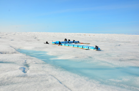
Deployment of an imaging radar array on Store Glacier, Greenland. (Photo credit: T. J. Young)
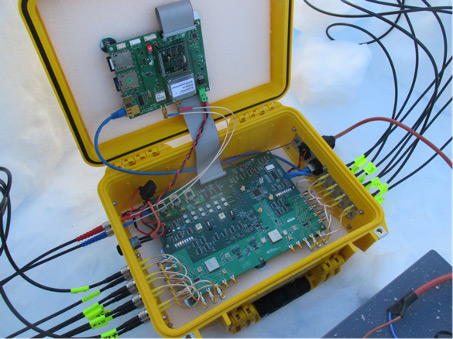
Field-ready radar electronics implementation.
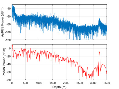
Radargrams measured at Dome C, Antarctica, using: (top) our ground-based low power radar and (bottom) an airborne high power pulsed radar.
- Prototype wireless sensors for monitoring subsurface processes in snow and firn
-
Geophysical radar
We also conduct radar engineering research to measure and better understand other geophysical phenomena such as avalanches, lava lakes and groundwater flow. We have supported radar hardware development in these specific areas, which have gathered experimental data from field trials in Austria, Morocco and Peru.
Key publications
- Radar Altimetry as a Robust Tool for Monitoring the Active Lava Lake at Erebus Volcano, Antarctica
Peters, N.J., Oppenheimer, C., Brennan, P., Lok, L.B., Ash, M., Kyle, P. 16/09/2018 In: Geophysical Research Letters. 45, 17, p. 8897-8904.
Funding
- Royal Society
- Royal Academy of Engineering
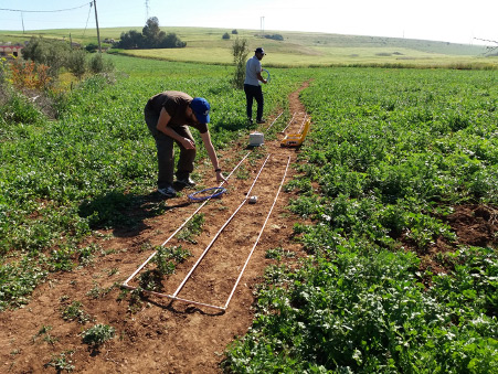
HF radar to measure groundwater (Photo credit: C. Martin)
- Radar Altimetry as a Robust Tool for Monitoring the Active Lava Lake at Erebus Volcano, Antarctica
-
RF and microwave electronics
High frequency active and passive circuit design underpins the research that we do here at Lancaster University Engineering Department. This includes research into RF metrology techniques and characterisation of circuits integrated onto printed circuit boards (PCB) up to mm-wave frequencies.
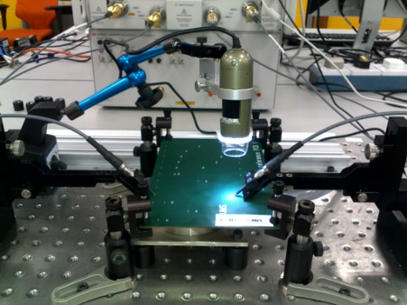
Microwave PCV probe measurement
Further reading
People
Collaborations
- British Antarctic Survey
- University College London
- Cardiff University
- University of Cambridge, Scott Polar Research Institute
- University of Glasgow, School of Multidisciplinary Studies
- EcoSwell
- Analog Devices, Inc.
Funding
- Royal Society
- Royal Academy of Engineering
- Natural Environmental Research Council
Facilities
We are equipped with a high-frequency probing facility for single-ended and differential measurements of microwave PCBs and components (to 20 GHz). This is supplemented with a temperature-controlled test chamber enabling PCBs and electronic sensors to be tested from -40°C to +130°C. We are also well supported by our School with access to an extensive range of electronics test and measurement equipment, PCB milling, surface-mount assembly, mechanical workshop and anechoic chamber facilities.
Software
- NI Microwave Office
- CST Microwave Studio
- Cadence Orcad
- Eagle PCB
- MATLAB
- Xilinx Vivado