|
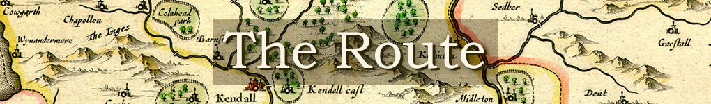
The Route Click on the thumbnails for photo-credits and further links.
‘And among the hills, dales and mountains he came on, and convinced many of the Eternal Truth’ 1 The Journals do not provide a detailed itinerary of Fox's route in 1652-1653. He moves from place to place, and from event to event: ‘And from thence I came to Preston Patrick Chapel: where there was a great meeting appointed’, ‘And after this I went to Lancaster with Judge Fell, to the Sessions’. He almost never mentions the road, or indeed the scenery.
There are exceptions: Pendle Hill, the Glastonbury Tor of the North, is a striking example. Elsewhere the closest he comes to mentioning the environment is when it involves people or actions: when he is face down in Walney mud being pelted with stones by James Lancaster’s wife, or when he arrives at Brigham churchyard to find James Lancaster speaking under a yew tree. But as for roads, we are left to try and work out for ourselves how he may have got from A to B, or from C to D. Where did he stay?
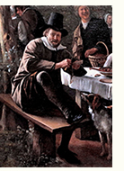
They all seem to have taken it as an obligation to take in travellers: ‘at night we came to a Country house; and there was no alehouse near, but they desired us to stay all night, where we had a good service there for the Lord, declaring his truth amongst them’.c (In Catholic times, ‘Entertaining the Stranger’ was one of the Seven Corporal Works of Mercy.) Part of the function of a large household like Swarthmoor was to be hospitable: ‘our house being a place open to entertain ministers and religious people at, one of George Fox his Friends brought him hither’.3 The Fells were not alone in this: it was an accepted characteristic of the English gentleman ‘to maintaine honorable hospitality’.4 Funeral eulogies in contemporary Lancashire and Cheshire praise this: Secondly, he was to be commended, for his Hospitalitie. It is well knowne, his house was seldome without strangers. I may in some sort compare him to Abraham and vnto Lot; they sate in their gates & at the doores of their tents, to inuite strangers. And this gentleman desired his friends & neighbours to come to his house, and they were vnto him welcome guests. In this respect he was like vnto Job, he did not eate his morsels alone.5 Margaret Fell not only took in Fox, she welcomed James Naylor and Richard Farnsworth when they came looking for him: ‘after James Naylor and Richard Farnsworth followed him, and enquired him out, till they came to Swarthmore, and there stayed a while with me at our house, and did me much good’.6 Other travellers confirm that one stayed with friends or relations where one could, and at inns for the rest of the time. We know the names of the inns (and often their landlords and landladies) in the 17th century all the way from London to Kendal. How did he travel, and what were the roads like?
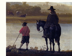
One would like to be able to calculate how far he could travel in a day, but his timekeeping is not often precise enough for that. Bootle to Brigham is 36 miles, but did he do it in one day (on horseback) or two? When Ralph Thoresby made his expedition on horseback from Leeds to West Cumbria in 1694, he appears to have covered about 37 miles a day, if he was not distracted by antiquarian pursuits. Even crossing the Lake District by Wrynose and Hardknott Passes, which he found terrifyng, he managed 37 miles, though partly because there was no hostelry before Calder Bridge. On foot, one First Day (Sunday) Fox tells us he went from Newton-in-Cartmel to Staveley and back (3.6 miles each way), and then in the afternooon to Lindale and back (2.4 miles each way: he says ‘two or three miles’), a not excessive walk, though he did combine it with a major altercation after the service at Staveley when he was thrown over the church wall but persisted with the conversation in the local alehouse, and another more successful intervention at Lindale. Road conditions in the North West could be difficult if not downright dangerous at the best of times. Three travellers in 1634 came down the main route from Penrith to Kendal through such wayes as wee hope wee never shall againe, being no other but clim(b)ing and stony, nothing but Bogs and Myres o'r the tops of those high hills so as wee were enforc’d to keepe these narrow, loose, stony, base wayes, though never so troublesome and dangerous ... On wee went for Kendall, desiring much to be releas’d of those difficult and dangerous wayes, which for the space of eight miles travelling a slow marching pace we pass'd over nothing but a most confus’d mixture of Rockes and Boggs.7
All this makes it likely that he stuck to the beaten track. The post-Romantic image of him striding over the hilltops by untrodden ways is purely our fantasy. He was in any case looking for people, preferably in large numbers, not out to enjoy the scenery. There is no reason to believe that he did not behave like any other 17th-century traveller, planning his way by known routes, and when he decided to strike off into the unknown, putting himself in the hands of people who knew the way. His route moves from person to person (even if in the Yorkshire Dales he does not always remember their names) and (established) meeting-place to meeting-place, whether it is a chapel of ease, a market, or a hillside. We need to find out what these tracks were. How do we know?
If going by the main road does not sound very adventurous, we should remember that, as we have seen above, ‘main’ is a relative term. Besides this, some of the roads we take for granted now were not there then. The main North Road out of Lancaster did not follow its modern route along the A6 (now superseded by the M6), but branched right at Carnforth to go through Burton in Lonsdale and then up what is now a very minor road indeed through Crosscrake and Natland to Kendal. The modern stretch of the A6 from Carnforth to Milnthorpe was a moss (marsh), only conquered in 1819-1822 by Macadam. It still has unexpected teeth-rattling subsidence bumps by Beetham. The road from Wensleydale to north Craven was along the Roman road from Bainbridge to Gearstones, a main turnpike from 1751, now demoted to a ramblers’ route when the inhabitants of Hawes got a completely new turnpike (now the B6255) in 1795. The road from Westmorland to Durham, the A66, however, still runs along the old Roman road.
More information can be found in official documents, minutes of local government (including parishes) which was tasked with keeping the road system passable, in both senses, and in the documentation, including Acts of Parliament, around the later Turnpike Acts. Many of these are collected or summarised by the historian John F. Curwen in his Records Relating to the Barony of Kendale: Volume 3 and The Later Records Relating to North Westmorland or the Barony of Appleby.11. An invaluable resource for the area is the magisterial Old Cumbria Gazetteer by Martin and Jean Norgate. 1. Margaret Fell The Testimony of Margaret Fox concerning her Late Husband George Fox prefaced to the 1694 edition of the Journal. Return 2. There is a very good chapter on this and its reciprocal nature in Ben Jonson's Walk to Scotland edited James Loxley, Anna Groundwater, and Julie Sanders (Cambridge University Press, 2015, paperback 2017) pages 171-198, Appendix 3, ‘Scenes of Hospitality’. Return 3. Margaret Fell The Testimony of Margaret Fox concerning her Late Husband George Fox. Fox does not mention who this was. Return 4. William Segar Honor military, and ciuill contained in foure bookes (London: Robert Barker, 1602) 230. Return 5. Richard Eaton A sermon preached at the funeralls of that worthie and worshipfull gentleman, Master Thomas Dutton of Dutton, Esquire who yeelded to nature the 28. of December. By Richard Eaton Bachelour of Diuinitie, and pastor of Great Budworth in Cheshire (London: John Legatt for Samuel Mann, 1616) 21-22. Return 6. Margaret Fell The Testimony of Margaret Fox concerning her Late Husband George Fox. Return 7. Being a Relation of a Short Survey of 26 Counties, briefly describing the Citties and their Scytuations, and the Corporate Towns and Castles Herein. Observed in a Seven Weeks Journey begun at the City of Norwich, By a Captaine, a Lieutennt. and an Ancient, All three of the Military Company at Norwich British Library Additional MSS. 34754, pages 19–20, quoted by Curwen 'Records of Kendale: The main roads', in Records Relating to the Barony of Kendale: Volume 3 edited John F. Curwen (Kendal: Titus Wilson 1926) 1-20. Online at http://www.british-history.ac.uk/kendale-barony/vol3/pp1-20. Return 8. The Journeys of Celia Fiennes edited Christopher Morris (London: The Cresset Press, 1949) 190, 192. She is worried about her horses, ‘for these stony hills and wayes pulls off a shooe presently [almost at once] and wears them as thinn that it was a constant charge to shooe my horses every 2 or 3 days’, though fortunately somewhere near Ambleside she manages to find a very good smith, who ‘did shooe them so well and so good shooes that they held some of the shooes 6 weeks; the stonyness of the wayes all here about teaches them the art off makeing good shooes and setting them on fast’ [197]. Return 9. The Diaries of Lady Anne Clifford edited D.J.H. Clifford (Stroud: Sutton, 1990; pb Cheltenham: History Press, 2009 and reprints) 189 etc; 261-2. Return 10. David Harrison The Bridges of Medieval England (Oxford: Clarendon Press, 2004) 222-230. Return 11. 'Records of Kendale: The main roads' in Records Relating to the Barony of Kendale: Volume 3 edited John F. Curwen (Kendal: Titus Wilson, 1926) 1-20, online at British History Online; The Later Records Relating to North Westmorland or the Barony of Appleby edited John F. Curwen (Kendal: Titus Wilson, 1926) 3-8, online at British History Online. Return |