The main Matienzo Expeditions occur around Easter and from the middle
of July to the end of August. In the latter period, most activity happens
during the last week of July and the first two weeks in August.
New cavers, experienced and novice, are welcome: fresh perspectives
and enthusiasm often leads to new cave discoveries!
This page gives a flavour of what goes on above and below the Matienzo
area.
Contents
The Area
Permissions, Grants and Fees
Camping and Catering
Caving Organisation
People
Caving
Caving Areas
Publications
Cave marking
Conclusions
More information
Shortened Bibliography
The Area
The 26km2 enclosed depression of Matienzo has taken some 2
to 3 million years to form. The imperviously-floored valley is surrounded
by limestone hills. Water resurges into the basin at a number of points and
leaves at the northern end.
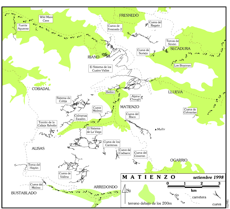
A major Spanish expedition took place in the area in the summer of 1964. British caving expeditions to Matienzo have been occuring up to 3 or 4 times a year since the late 60‘s and the amount of known cave passage has risen from some five or six km to over 223km (February 2001). At present, four or five kilometres of cave are found each year, although in 1989 over 15km was surveyed. Collaboration with Spanish caving groups often results in new cave exploration. An area map shows the major caves.
Permissions, Grants and Fees
Permission to cave is given by Spanish speleological authorities within
both geographical (about 60km2) and time limits. We were refused
permission to cave during 1990 because caving occurred outside our designated
area. Please do not cave beyond the permit boundaries. The permit runs for
the full year.
Good relations are kept with the villagers, the caving authorities, other spanish caving groups and the Guardia. We have the support of the Ghar Parau Foundation which recommended a UK Sport grant of £600 to Matienzo 2001. To supplement this, it is likely that the expedition will ask for £10 maximum from all non- wage-earning cavers, and £1 per day from wage-earning cavers up to a maximum of £20. This covers transport costs to caves, all group equipment (ladders, rope, bolts, carbide, rescue equipment, etc), surveying, publication costs, some photographic costs and gifts. (There is also a charge for camping - see below).
Camping and Catering
Tents can be erected on the field behind the bar. Only the eastern half
of the field should be used and, as it is used for grass crop, vehicles should
only drive on when the ground is dry and hard. 'Domestic' refuse should be
disposed of by throwing it in the wheelie bin found on the main road.
There is a toilet block in the middle of the campsite which has showers, wash basins and toilets: an outside tap is for drinking / cooking water and washing equipment. There is a rota for giving the facilities a quick wipe over.
A room in the block acts as a tackle store and is used for charging electric cells.
Pablo at the bar charges 400ptas per adult per night for camping, up to a maximum of 6000ptas. This will be collected by the expedition and paid to Pablo as a lump sum at the end.
Everyone looks after themselves for catering, although alternative food arrangements can be made when long trips are likely. Tinned goods, fresh eggs and some vegetables can be bought at the bar, but many people prefer to shop at the supermarkets on the way to the beach or at Ramales, the nearest large town where travellers cheques can be cashed or cash cards used. Many oldtimers find a cool box and ice packs (re-frozen in the deep freeze at the bar) a necessity to keep meat and veg edible. The new restaurant, at the edge of the campsite, opened in 1994, has also altered some eating habits!
Pablo and Anna at the bar have been very amenable about supplying late butties, up to about midnight, but this depends on the supply of bread and cannot be relied upon. The bar opens at about 10-30am (depending on the previous night's activities) and will serve an English breakfast. Bread is delivered to the bar around 10-30am and should be ordered the night before from the expedition bread orderer. Each order should be collected from the bar and paid for individually.
Self catering can be supplemented by eating out, either at Pablo's, Bar Tomas in Ogarrio, the Arredondo, etc. There is often an expedition meal at the height of the caving frenzy.
Caving Organisation
Most of the cavers who come to Matienzo are not here primarily for the
sport - they are people fascinated by the potential of the area and who pit
their speleological wits against the draughting holes, deep shafts and tight
crawls which could lead to 'caverns measureless'.
Caving trips occur because a number of people see the need for them. There are few organised 'tourist trips' - the best way to see the caves is to get involved in a series of working trips - pushing, surveying, photographing etc. Anyone can organise a trip and, apart from the specialised (e.g. diving) ventures, all trips are open to everyone. Obviously, each team on a major push/survey will have at least one person who has been in the system before and might well be the 'system expert'. Because systems tend to be pushed over a number of years, it is better that as many people as possible get to know a cave, rather than just one team. British Clubs count for nothing in Matienzo - we are the Matienzo Caving Club; everyone should feel part of a whole expedition and be prepared to cave with anyone of similar caving aptitude.
Trip Sheets should be used to aid the organisation of the various parties that are likely to set off each day. The initial details of cave, objectives, date and number of cavers required are filled in by the trip leader(s) and cavers can then sign up for whatever takes their fancy.
Every caving team is likely to explore new passage. Each group should survey the passages as they leave the system so that the survey can be computer-drawn later that evening, allowing the next team to concentrate on the best leads. Each team therefore has the responsibility of ensuring that the survey data is converted to co-ordinates the same day and a survey drawn over the computer centre-line print out as soon as possible. An account of the new explorations should be written in the log book immediately and a sober description of the passage should also be written down or spoken onto audio tape in due course.
Surface prospecting is also a vital part of the expedition but needs to be researched beforehand. Maps (1:5000) and markers, etc should be taken into the field. (See Publications and Cave Marking below). The expedition has a digital camera that can be used for surface or underground recording and a number of people have GPS equipment for positioning entrances.
We are extremely fortunate in having the use of the bar facilities for a base. We are allowed to use a screened-off corner of the restaurant as a computer room / library and survey drawing-up area. The restaurant should not be seen as a general extension to the bar as Spaniards (and English) are paying to dine out!
People
Some members of the expedition have a general responsibility for overseeing
certain major aspects. However, individuals should still see themselves as
being responsible for the tackle they‘ve used, writing up, survey drawing
etc.
The above can advise on areas and/or caves to push. Many other members of the expedition have expertise in all matters speleological. A number have been around Matienzo for years and will give advice.
Caving
Personal caving equipment is obviously the responsibility of each caver;
lump carbide may be provided and FX cells (and other rechargeable cells)
can be charged in the tackle store. Group equipment is the responsiblity
of the team using it. If a system is detackled, the detackling group should
normally clean up the equipment removed. Depending on the cash available,
some petrol money is paid to drivers who transport cavers.
A number of caves around Matienzo are important as archaeological sites. Pete Smith has carried out research and catalogued the various artifacts and paintings. Please keep your eyes peeled, looking at the walls and floor in any site that may have been inhabited.
Each individual on underground ventures is responsible for his / her own safety and should have a blanket, spare light, etc. Sensible caving procedures should be adopted, e.g. lifelines on ladder pitches, remembering that rescue is likely to be a protracted and costly affair. Rescue call-out should be via the bar and to the Guardia. A number of the expedition are CRO members and would organise rescue procedures. Taking out BCRA Insurance or a similar scheme is vital for peace of mind and pocket. Details of 2001 insurance prices can be found on the BCRA web site. People without caving insurance are not permitted to cave.
Caving Areas
Within our 60km2 there are caves and pots of all sizes. The
major cave networks are the 4 Valleys System at 42.8km and the South Vega
System at 25.3km long and 305m depth. Pushing these systems is a priority,
as is finding new caves on the surface. The area does not have a great depth
potential, the maximum is about 680m.
The area map shows the main caves, roads and rivers. The following thumbnail descriptions aim to give a general feel of the area.
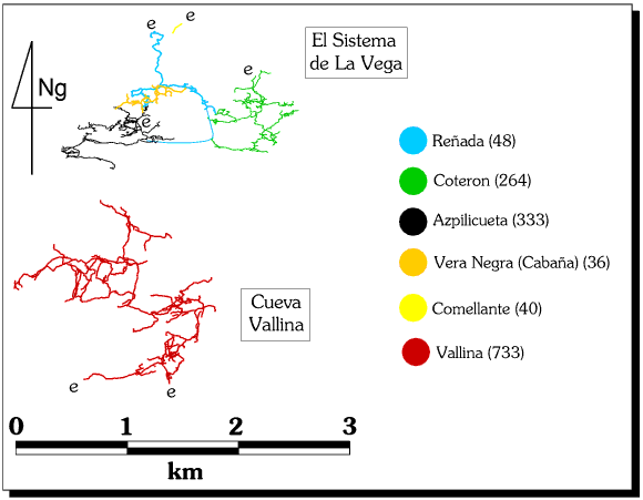
The South Vega System
(survey)
Azpilicueta (333) and
Coteron (264) are the high level entrances
which drop down to valley level and emerge at
Reñada (48). Cueva-Cubio de la Reñada
contains a river which resurges into the depression to flow across La Vega;
some of this water could come from Hoyon (567).
Potential lies to the south (with Cueva Valline)
and to the west.
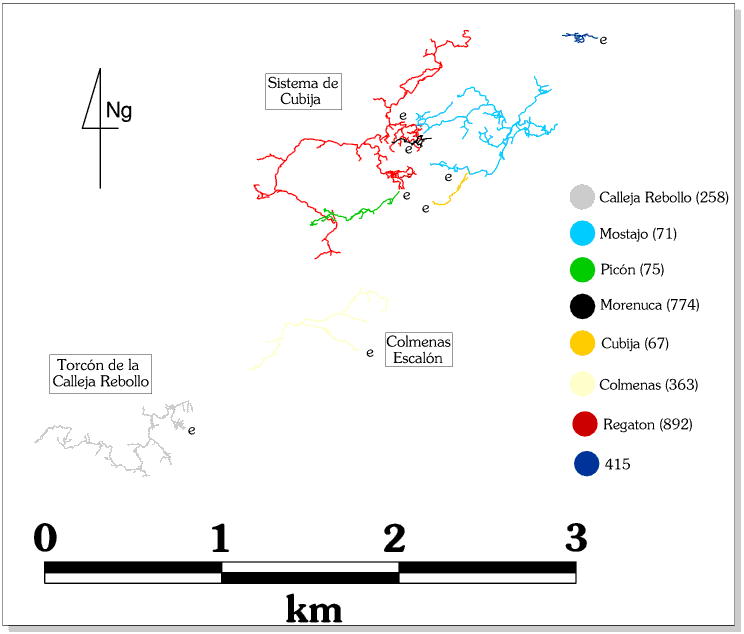
North Vega
(survey)
Torcon de la Calleja Rebollo (Toad in the
Hole - 258) is an expanding system which could go anywhere: northeast
to link with Mostajo (71), north and west
into the unknown or even south to link with
Reñada.
Mostajo (71) could go northwest to emerge
in cave 415, or north into the unknown. Both
caves are mainly dry.
Cubio-Regaton-Mostajo has a length of 17.9km, is in a prime position for extension, and is still wide-open in places.
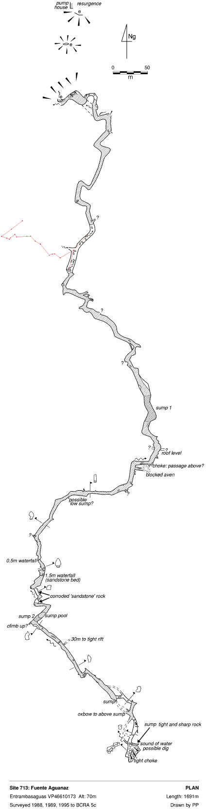
The area of Cobadal may also drain into a system from this area. The resurging river of Fuente Aguanaz (713) (survey), 7km to the north may also have something to do with these caves.
The Four Valleys System
(survey)
All the water in the depression leaves through
Carcavuezo (81), passes through
Cueva Llueva (114), with an entrance in Llueva
Valley, and resurges in Los Boyonnes (117)
in Secadura. The cave is fed from water in Cueva
Hoyuca (Uzueka) (107) which in turn is fed by water in
Cueva Riano (105). The caves of Hoyuca, Riano,
Llueva and Carcavuezo have been joined to give a 42.8km length. Some estimates
put the potential passage at more than 100km.
Muela/Mullir
This area is approximately 10 km2 of high level karst with
little horizontal development. There are more than 200 known shafts, by no
means all explored. There is a great deal of surface prospecting and underground
exploration waiting to be done. If an integrated drainage system exists,
the resurgence could be the one below Cobrantes
(110). It seems more likely that local networks exist with water resurging
at various points around the mountain, e.g. at Ogarrio, and into known systems,
e.g. Llueva, Carcavuezo.There is a Muela field hand-book listing and describing
all the Muela sites and highlighting those which are unexplored.
Publications
There are over 150 references to various articles (Spanish and English)
and many of these articles are in boxes in the back room of the bar. If you
are interested in a site, look in the card index where all explorations and
accounts are catalogued and then read up the various references. The books
likely to be of most use for general reading are listed below in a short
bibliography.
Maps are available for the whole of our area at a scale of 1:5000 (1cm = 50m) and 1:25000. The large maps have all known cave sites plotted on and so must not leave the bar. There are A3 photocopied sections of these maps which should accompany everyone who is surface prospecting. Plastic wallets are available for weather proofing. (see Cave Marking, below).
All sites details are kept in a card index and computer database.
A publication based on cave descriptions from the web site (Matienzo Under ground) circulates, and people should feel free to add to it or amend it. Appendices order the caves by length, depth and altitude. There is also a list of the 'unexplored' sites, a list of digs, and sites of archaeological and biological interest.
Cave Marking
It is very difficult to permanently mark sites without disfiguring the
limestone! Before 1994 we used cow-tags which had painted and embossed numbers.
This system has fallen out of favour and another system needs to be used.
There is now much less need to mark caves as personal GPS equipment (without
the wobble) became useable in 2000.
Conclusions
There are 1607 sites in the area and the potential
for finding new passage remains as high as ever. But please remember to record
your finds so that exploration does not have to be repeated!
More information
Further details or any other help can be obtained from
Shortened Bibliography (mainly in English)
Matienzo Underground - the annually updated book, based on the web site. This shows the current state of (written) speleological knowledge about Matienzo.
(A) Fernandez Gutierrez et al, 1966. La depresion cerrada de Matienzo, Cuadernos de Espeleologia vol 2. 107pp + surveys & photos. The account of the original Spanish explorations.
(C) Kendal Caving Club/Manchester University Speleological Society 1975. Report of the British Expedition to Matienzo. 64pp + surveys + photos. The account of the expedition which surveyed about 15km in 6 months.
(T2) Mills L.D.J., Waltham A.C., 1981. Geomorphology of the Matienzo Caves. BCRA Transactions Vol 8(2), pp 63 - 84. Some speleogenesis hypotheses.
(T3) Smith P., 1981. Prehistoric remains and engrav ings discovered by the British Speleological Expeditions to Matienzo. BCRA Transactions Vol 8(2), pp 85 - 86.
(Y) Smith P., 1983. Iron Age Finds in Matienzo. BCRA Transactions Vol 10(3), pp 145 - 164. More up-to-date archaeological data is found for each cave in the Matienzo Update.
(BB) Corrin J., Knights S. 1988. Matienzo 1987 in Caves & Caving No. 41, Autumn 1988, pp 24-28
(BC) Davis J., Corrin J. 1989. Matienzo 1988 in Caves & Caving No. 44, Summer 1989, pp 13-17.
(BJ) Corrin J., 1990. Matienzo '89 in Caves & Caving No. 49 , Autumn 1990, pp 19 - 25.
(BO) Corrin J., 1992. Matienzo '91 in Caves & Caving No. 55 , Spring 1992, pp 11 - 13.
(BR) Corrin J., Quin A., 1992. Matienzo '92 in Caves & Caving No. 58 , Winter 1992, pp 2 - 6.
(BZ) Corrin J., 1994. Matienzo '93 in Caves & Caving No. 63 , Spring '94, pp 24 - 27.
(CS) Corrin J., 1994. Matienzo '94 in Caves & Caving No. 66 , Winter '94, pp 10 - 14.
Corrin J., 1995. Matienzo '95 in Caves & Caving No. 70 , Winter '95, pp 24 - 27.
Corrin J., 1997. Matienzo ('96) in Caves & Caving No. 75 , Spring ''97, pp 16- 18.
Corrin J., 1998. Matienzo 1997 in Caves & Caving No. 79 , Spring '98, pp 31- 32.
Corrin J., 1999. Matienzo ('98) in Caves & Caving No. 83 , Spring '99, pp 26- 30.
Corrin J., 2000. Matienzo '99 in Caves & Caving No. 87 , Spring/Summer 2000, pp 43- 46.
These last twelve photocopied articles outline the discoveries over recent years. A full bibliography is also available.