Tel: +44 (0) 1524 594178 Fax: +44 (0) 1524 594256 E-mail: sociology@lancaster.ac.uk
![]()
Research Cluster 2 - Creating the Catchment Knowledge Base
There were three parts to this research cluster:
2.1 Economic value, land and water
2.2 Social, Institutional and Environmental Interactions and the Creation of a New Perspective
Findings from the above three research activities can be found in the Summary Report of June 2011.
2.1 Economic Value, Land and Water
2.1a) Studying the Land
 Established survey methods (Carey et al. 2007) were employed to measure the ecological and landscape attributes of the land in the catchment. This involved an experienced landscape ecologist (Dr. Lisa Norton) recording habitats, landscape features and vegetation across the catchment using a ruggedized computer.
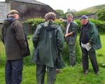
An agricultural/economic assessment of the catchment was made in collaboration with the farmers by local farm business advisor (John Rockliffe), who collected data on stocking rates, farm income, fertilizer application, and other parameters needed to create a farm P (phosphorus) budget. These field visits were observed by Dr. Norton and data recorded about the perception of land quality from farmers' and advisors' perspectives. Data collection during these field visits encompassed:
- Quantitative information on ESA agreements such as stocking densities, fertiliser applications etc. both historically and currently. The quantitative data provided a vital link between the aquatic and terrestrial ecosystems.
- Qualitative information was collected through interviews and questionnaires based on previous farm surveys (Fuller et al. 2005). These focused on farmers' perceptions of what constitutes good quality land and the influence of changing economic drivers on land management.
 2.1b)
Linking terrestrial and aquatic ecological monitoring
2.1b)
Linking terrestrial and aquatic ecological monitoring
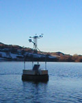
A monthly lake monitoring programme, using standard techniques, was carried out over 3 years. Additionally, after considerable consultation, a meteorological station with additional lake monitoring equipment was installed on a buoy on Loweswater. Data, down-loaded by telemetry, included: temperature profiles, oxygen concentration, temperature, pH, conductivity at surface and depth, and surface chlorophyll a. Data were uploaded to the project web-site. Further information please click here.
Fish populations were investigated using three approaches:
1) a historical perspective through a student dissertation;
2) analysis of unpublished data on recent fisheries performance in the lake and on fish abundance from electrofishing in its inflowing and outflowing streams provided by the NT and EA, respectively; and
3) scientific assessments of the lake’s fish community conducted in the summers of 2007, 2008 and 2009 combining night-time survey gill nets and hydroacoustic surveys during the day and night to produce information on fish species, abundance, individual condition and spatio-temporal distributions.
2.2c) Creating community and stakeholder informed decision-support mechanisms
Data from the research on terrestrial ecology and farmland economy were combined to identify links between management practices (current and historic), the agricultural/economic potential of land, and the environmental quality of both land and lake under a range of potential policy drivers. This was achieved in the following way:
Terrestrial ecology and farm management data were incorporated into a geographical information system (GIS) enabling land management practices to be linked to the environmental quality of the land. The modelling methodology used a series of linked models to assess Phosphorus (P) runoff from the catchment to the lake and its impact on water quality. Outputs from a farm nutrient budget model, Planning Land Applications of Nutrients for Efficiency and the environment (PLANET), fed into a hydrological model (GWLF) and nutrient outputs from the hydrological model fed into the algal production model (PROTECH).
In order to fully parameterise these models; alongside the GIS information, land management information from the farmers, meteorological data from the in-lake buoy, and hydrological data from the catchment were used. In-lake data from the automatic buoy was used for model validation.
In addition to a ‘current conditions’ scenario, as input to the model, four further scenarios were explored to reflect alternative land management options. Non-farming scenarios included a wooded (deciduous) catchment (‘woodland’ scenario), and a no-input grassland scenario without livestock (‘natural grassland’). Farming scenarios included: ‘no cattle, double sheep numbers’ and ‘double cattle, half sheep numbers’ representing potential, though extreme, changes in the livestock composition of the catchment. Nutrient loads from septic tanks (from an LCP study by Webb, 2010) were input to the GWLF model in two ways: 1) as a diffuse source of nutrients where P discharge from septic tanks was incorporated into the farm nutrient budget in the same way as other sources of nutrients; and 2) as a point source of nutrients where effluent was assumed to discharge directly to the watercourse, i.e. a worst case scenario.
2.2 Social, Institutional and Environmental Interactions and the Creation of a New Perspective
Existing institutional arrangements pertaining to agriculture, water resources, environmental protection, spatial planning, economic regeneration, local and regional government, tourism and recreation can all provide both opportunities and constraints for the development of integrated catchment management initiatives. To generate an understanding of which of the above sectors and policies most affect Loweswater, and how, was important to this project. Research data on this was collected using a variety of different methods including:
- interviews with key representatives for local, regional and national organisations responsible for land and water at Loweswater;
- analysis of legislation, government/agency reports, policy documents and other literature;
- participant observation at public meetings and events.
2.3 Local Knowledge
Whilst the research on institutional and policy context above concentrated
on institutional structures and cultures, local knowledge that exists about the catchment and about management
of land and water within the catchment was also explored. Memories of past catchment management
practices are very important, as is the development of an understanding
of the complex inter-dependencies of social and natural systems and practices
in the present.
38 semi-structured interviews were carried out as part of the research between March 2008 and September 2009, all with people who either lived in or had at some time lived in the catchment area, or had knowledge and experience of it relevant to the study. We estimate that at the time of the study, there were a total number of 19 permanent households in the catchment and 1 holiday home that was occupied for some part of the year. Around 43 people lived permanently in the catchment during the time of the study. We also interviewed 7 out of the 8 farmers with in-bye land in the catchment. The farmer who declined to be interviewd occasionally participated in LCP meetings. Interviews were based around respondents' understandings of and feelings about:
- Living in Loweswater
- Making a livelihood in Loweswater
- Cultures, sub-cultures and social structures in Loweswater
- Land and lake management
- Management of wastes
- Problems and tensions in the catchment
- Past land-use and management practices


| Community Noticeboard | Picture Gallery | Research Resources | Who's Who | Links |