Tel: +44 (0) 1524 594178 Fax: +44 (0) 1524 594256 E-mail: sociology@lancaster.ac.uk
![]()
The Research: Introduction and Background
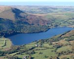
Loweswater is one of the smaller and more isolated lakes in the Western Lake District (1.25 miles in length, 0.5 miles wide, and 60 feet deep), and the only Lakeland lake whose waters flow inland.
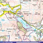
Loweswater lies within the Lake District National Park boundary. The land in the catchment (defined as the watershed) is part of the Department of the Environment and Rural Affairs' (DEFRA) Environmentally Sensitive Areas Scheme ; the lake and some of the surrounding land are owned by The National Trust and the waters are subject to regulation by the Environment Agency responsible for implementing the EU Water Framework Directive.
National Trust data and local knowledge both suggest that brown trout populations and game angling have declined In Loweswater. This has led to conflicting local views on how the fishery should be managed in the future (Buttermere and Ennerdale Property Fisheries Review Meeting, December 2005). A provisional assessment of water quality at Loweswater in terms of the EU's Water Framework Directive suggests that water quality is only 'moderate' (Maberley et al, 2006), and future management action is necessary to achieve the 'good ecological status' demanded of such water bodies by 2015.
In 2002, local farmers took the initiative to do something about the state of their lake and formed the Loweswater Improvement Project. Follow the link to the Loweswater Improvement Project to see their achievements to date.
The present project, enabled by the Rural Economy and Land use Programme (RELU), is rooted in the findings of two smaller studies carried out in the Loweswater catchment in recent years. The first study investigated the potential impacts of farm management practices on lake water quality. The second, a scoping study, was aimed at understanding ecological, economic and social interactions within the catchment.
Download Documents
- A report of the impacts of farm management practices on the lake
- A leaflet about this research
- A report of the scoping study
- A paper arising form the scoping study
- An investigation of the water quality of Loweswater done for the Environment Agency (2000)
- A full description of the present research
The research supported by RELU had a strong interdisciplinary focus and expanded on these earlier studies to encompass social, cultural, economic and policy dimensions in addition to the study of ecological interactions. The study valued the knowledge and experience of local people as much as it did more formalised knowledges about the local environment and recognized that it is only with local stakeholder involvement as well as with that of institutional stakeholders that more sustainable ways of managing the Loweswater catchment area could be devised and implemented.
One of the main objectives of the research was to create a new institutional mechanism or a 'new collective'. This collective was initially referred to as the Loweswater Knoweldge Collective (LKC), and once founded, was re-named by participants as the Loweswater Care Project (LCP). It consisted of local people (those living within the parish boundaries), people from further afield who wished to participate, institutional stakeholders, researchers, and others. We all worked together to find out more about the Loweswater catchment and how to live in it in more sustainable ways.
The LCP was set up by the local community, stakeholders and researchers as part of the research project. It infused, strengthened and challenged the work of the different research clusters and linked them together in various and sometimes unanticipated ways. It also proposed additional research and activities (see below), which greatly supported the collective approach to understanding and acting in Loweswater.
LCP Research Projects
Loweswater Care Project participants were enable through a grant of £35,000 (allocated for that purpose in the original funding application to the Rural Economy and Land-Use Program (RELU)) to carry out research in an area of their interest. A call for research project proposals went out in February 2009 through the LCP, and five proposals were approved for funding. A summary of these proposals can be found here.
For PROJECT REPORTS please go to the Research Resources page.
Modelling Report
Lisa Norton and Stephen Maberly and colleagues' power point presentation on the modelling aspects of the RELU project has now been moved to the Research Resources page.


| Community Noticeboard | Picture Gallery | Research Resources | Who's Who | Links |