
CiFR-Lancaster
Flood mitigation effectiveness of NFM interventions within the Cumbria Innovative Flood Resilience project
1 Nov 2021 to 31 Mar 2027
(Update 2025-27: technician monitoring/QA contract full-time to 17 Dec 2026; PI 12 days in 2025 and 10 days in 2026 for management (staff and project meetings), plus 5 days in 2025 and 16 days in 2026 for fieldwork, iML modelling and reporting/presentations, and 3 days Jan-Mar 2027 for CiFR-Lancaster report prep)
Short link: https://bit.ly/CiFR
This Lancaster-led R&D project is Workstream 3 (WS3) of the Cumbria Innovative Flood Resilience project (CiFR). CiFR is a £6.5M project within the £150M EA/Defra Flood and Coastal Resilience Innovation programme (FCRIP). This programme is about delivering NFM (Natural Flood Management) and SuDs (Sustainable Drainage systems) schemes at larger scales than previosuly attempted, in part, by utilising innovative scientific approaches and technology. It is, therefore, a 'Research-by-Doing' programme. The primary objective of CiFR-Lancaster is to install and maintain Lancaster University owned stream level and rainfall stations (within 2022-26 period) to quantify the effectivess of NFM temporary storage features to be installed by others upstream of selected communities at risk of flooding. The effectiveness assessment primarily focuses on the flood-mitigation benefits of adding flood-only storage during rainevents causing overbank flows downstream, but also the tools needed to quantify the co-benefit that NFM interventions may have for mitigating water pollution.
Key observational measures of flood-mitigation effectiveness in the CiFR R&D project based on fundamental science advances from the NERC Q-NFM project:
Observational measure 1: What are the relevant level-hydrographs of an NFM flood storage feature (based on return period of the levels in a local channel producing property flooding from overbank flows downstream)?
Observational measure 2: With reference to the local rainfall to local channel (level or discharge) celerity in flood events - does the NFM feature have optimal timing for flood mitigation before starting to fill and then largely empty?
Observational measure 3: Where the continuous volume time-series of an NFM flood storage feature is observable (i.e., large depth change relative to area), how much volume capture is possible relative to local channel discharge within 2 hours of peaks (previously/currently) causing downstream property flooding?
Key observational measure of the effectiveness of water quality mitigation (NFM co-benefit) are developed in the CiFR R&D project based on fundamental science advances from the NERC DURESS and Changing Water Cycle projects:
Observational measure 4: Using continuous monitors, what accuracy at each point in time and temporal sampling frequency is required to quantify accurately the changes through flood events of key water quality variables of phosphate, nitrate, turbidity and salt concentration in studied streams in Cumbria?
Use of Lancaster's CAPTAIN Toolbox for Matlab, which is an Interpretable Machine Learning (iML) approach by virtue of the parsimonious nature of our Data-Based Mechanistic framework, is an essential component of the analysis of these observational data (see e.g., Beven et al., 2026).
CiFR is focusing on the following communities-at-risk of flooding using a network of gauging stations across Cumbria:
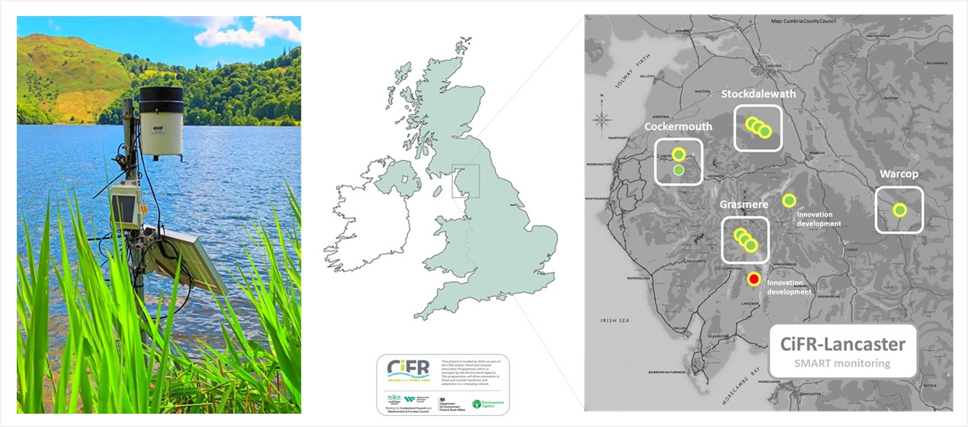
The LU-owned Grasmere lake rainfall, level and temperature station (left) and CiFR-Lancaster network in Cumbria, UK (right).
via MetronVIEW) no public interface (Station 1)
(live nitrate data by microfluidics via Metasphere) no public interface (Station 5)
(live nitrate and turbidity data by UV-Vis via Grafana) no public interface (Station 6)
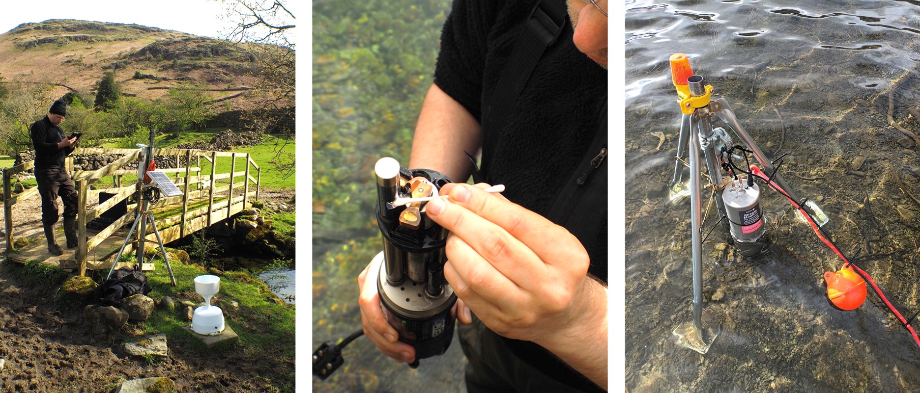
The LU Far Easdale baseline stream level monitoring station (left), servicing of LU Rothay water quality sonde (centre) at EA Grasmere level station, and LU micro-fluidics nitrate probe at Grasmere lake-edge (right).
(for live public access to level graphs for flood alerts
contact n.chappell@lancaster.ac.uk with your details for username and password) This asset was purchased by Cumbria County Council and transferred to Westmorland and Furness Council. It is currently maintained by Lancaster University
(offline rainfall via Kalyx-RG (Station 8))
Cameras monitoring floodplain engagement (Station 9ab)
Wythop Moss channel storage (three U20L04 stations for control and intervention reach: Stations 10abc)
Westray kest-based, floodplain storage (U20L04 and camera: Stations 10de)
LU Bitter Beck raingauge and discharge flume (left) and LU Sware Gill raingauge and flume, adjacent headwater to Tom Rudd Beck (right).
via MetronVIEW) no public interface (Station 13)
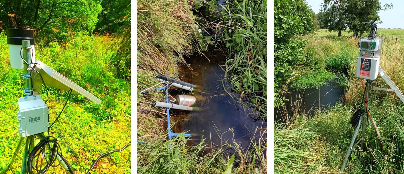
The LU Upper Roe stream level monitoring station (left), LU Upper Ive water quality station with phosphate sonde and turbidity system (centre), and LU Upper Ive level monitoring station (right).
(live discharge and level data via Fathom Scientific AutoSalt) no public interface (Station 14)
(live phosphate data by microfluidics via Metasphere) no public interface (Station 15)
(live nitrate data by microfluidics via Metasphere) no public interface (Station 5 as above)
(live nitrate and turbidity data by UV-Vis via Grafana) no public interface (Station 6 as above)
including Section 82 (Environment Act, 2021) turbidity data
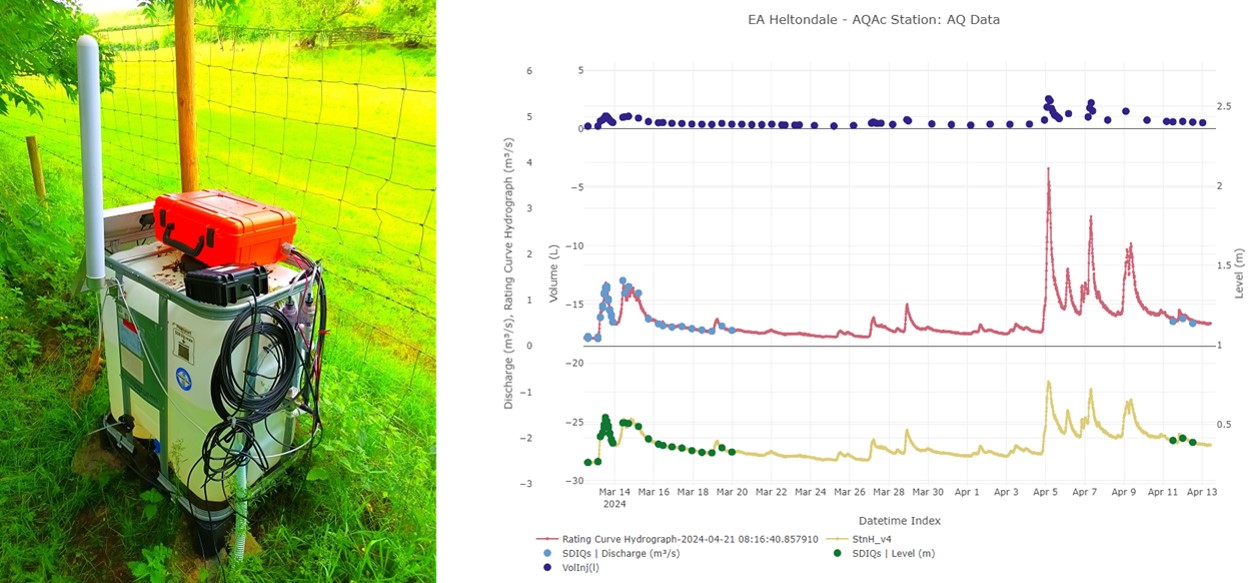
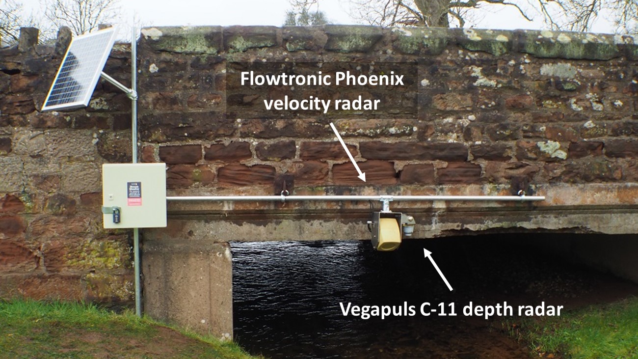
For example, an LU continuous dilution gauging unit (left: 'Fathom Auotsalt') and example NaCl gauging times for EA Heltondale gauging station (right)
Both stations upgraded to new 4G telemetry with live discharge and volume on 26 Jan 2026.
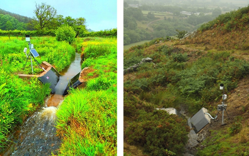
The LU Eggerslack net rainfall and discharge flume (left), and LU level (and live volume) monitoring station at the Grange floodplain bund (right) - see Chappell and Beven (2024).
The CiFR-Lancaster project has four core objectives:
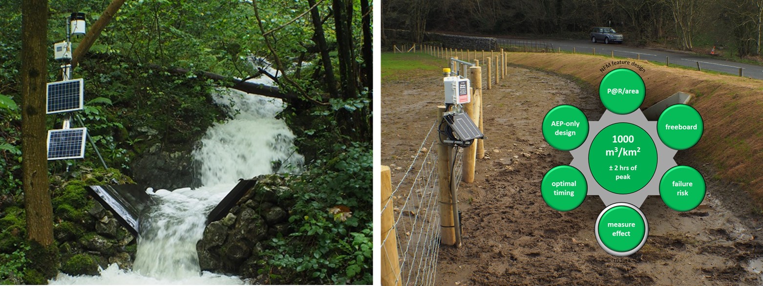
- Objective 1 Monitor storage change (using U20L04 loggers) during flood events in added NFM features (once built by CiFR-WS1), against a local reference stream-level and/or discharge records. Discharge-enabled stations use a 430 L/s trapezoidal flume to an LU design. This objective involves quantifying NFM storage behaviour, and hence flood mitigation effectiveness, in rainevents producing overbank flows from problem streams.
- Objective 2 Develop novel water quality monitors (for phosphate, nitrate and turbidity) combined with interpretative Machine Learning (iML) as a new tool to show the co-benefits of NFM for the mitigation of water pollution, particularly in highly dynamic flood events.
- Objective 3 Assist CiFR Workstream 1 (WS1) in the design of the NFM interventions and their placement, with support from subcontractee JBA Consulting (via additional funding in EAA7861XS01).
- Objective 4 Install and maintain additional telemetry and associated interpretative Machine Learning (iML) using Lancaster's CAPTAIN models (via additional funding in EAA7861XS01).
Funding sources
Environment Agency (EAA7861) via Cumbria County Council 2021-24, then Westmorland and Furness Council 2024-27
Environment Agency (EAA7861XS01 for objectives 3 & 4) via Westmorland and Furness Council
Investigators
Nick A Chappell (PI), Keith Beven (CoI), Wlodek Tych (CoI), Field-data Technician David Mindham (CoI) and subcontractor JBA Consulting (Barry Hankin)
Project partners
Cumbria County Council (2021-24), Westmorland & Furness Council (2024-27) - CiFR lead organisations; Environment Agency; JBA Consulting; Cumbria CVS; Natural England; 3Keel LLP; Cumberland Council.
Outputs
Beven, K. and Van Stan, J.T. 2026. Stemflows and preferential flows: A historical review and challenges for the future. Hydrological Processes, 40(5): e70556. doi.org/10.1002/hyp.70556. view online
Beven, K.J., Mindham, D., and Chappell, N.A. 2026. The Great Catchment Hysteresis Challenge. Hydrological Processes, 40(4): e70438. doi.org/10.1002/hyp.70438. view online
Chappell, N. 2025. Ensuring NFM investment mitigates floods: objective-based monitoring-analysis. Landscape in a changing climate conference: Cumbria and the North West, Kendal, Cumbria on 9 Oct 2025. view presentation (pdf)
Chappell, N. 2024. SMART watersheds to inform NFM design. The evidence behind Natural Flood Management conference, Milnthorpe, Cumbria on 14 Nov 2024.
Chappell, N.A. and Beven, K. 2024. Nature-based Solutions for effective flood mitigation: potential design criteria. Environmental Research Letters, 19(7): 074006. https://doi.org/10.1088/1748-9326/ad4fa2. view online, or paper (pdf) and Supplementary Information (pdf)
Chappell, N.A., and Mindham, D. 2024. High frequency measurement of phosphate, nitrate, DOC and turbidity for NbS evaluation. Presentation at the 5th International Workshop on High Temporal Resolution Water Quality Monitoring and Analysis at the James Hutton Institute, Aberdeen, Scotland, 17-19 June 2024. view presentation (pdf)
Link to main project: EA FCRIP/FCIP webpage.
contact details:Lancaster Environment Centre
LANCASTER UNIVERSITY
Lancaster LA1 4YQ
United Kingdom
n.chappell@lancaster.ac.uk