
Final year Geography student Josh Fryer learns about the ways in which fire and ice have changed the landscape of Iceland on a field course to southern Iceland.
Four years ago when I first visited Lancaster University on an Open Day, I heard the Iceland field course being discussed and thought what a brilliant opportunity it would be. At that time, it seemed like the trip was a long way off but my time at University has gone so quickly.
We met the two lecturers leading the field course, Professor Barbara Maher and Dr. Mark Hounslow, at Keflavik airport just outside Iceland’s capital city, Reykjavík. After an enjoyable flight from Manchester, it was exciting to land in Iceland to begin the week long field course. Our spirits were rather dampened by blustery winds and heavy rain. I hoped that the weather would improve luckily it did!
After taking shelter in the airport terminal whilst waiting for all 14 students to arrive, we met our tour guides for the week, who took us to our overnight accommodation. We spent the evening preparing ourselves for the week ahead and doing some ice breaker activities to get to know everyone on the trip.
To make the most of our time in Iceland, we were on the minibus for 9 each morning, ready for our adventures. Our focus, most of the time, was looking at how volcanoes and glaciers have, and continue to, shape the environment of southern Iceland.
Fire - gysers and geothermal activity
On our first day, field notebooks in hand, we set off on a tour of the Golden Circle, a popular tourist trail. We saw some amazing sights, including the famous Gullfoss waterfall and Geysir, one of the many locations in Iceland with geysers. The geysers erupt around every 10 minutes, shooting boiling water, heated by geothermal activity, into the air. At these stops, we also got the chance to practice field observation skills and to learn background information, which would prove very useful later in the trip.
After all that we were thankful to have some down time in the Secret Lagoon, an impressive geothermally heated pool, which gave us an opportunity to mix socially. Finally, after a long day we arrived at our overnight accommodation where we were provided with a brilliant warm buffet for our evening meal. Everyone made the most of being catered for, knowing that the next three nights we would be cooking our own food.
Mapping the landscape
The rest of the fieldtrip was focused on making sense of what we were able to see around us in the field. We visited a range of waterfalls, including the 60m Seljalandsfoss Waterfall, and several glaciers (-jökull in Icelandic). Everything we learnt and saw was recorded in our field notebooks.
We also had two days of mapping exercises, which involved learning lots of new skills such as pacing out distances to allow us to locate features and having scientific debates about the possible causes of these features. As there was such a large area to cover, the group split into pairs and started taking measurements of the proglacial zone (the area in front) of Sólheimajökull, an outlet glacier of the Myrdalsjokull icecap.
After carrying out lots of measurements and working out the best way to record all of our findings on the satellite image whilst preventing all of our hard work blowing away in the wind, we were finally finished. This made up an important part of the field course as it was part of the assessment and actually taught us a lot more than was initially apparent as it highlighted the diverse ways in which glaciers and volcanoes interact.
Ice - glaciers, icebergs and walking on ice
The area to the south of the Vatnajökull ice cap, the largest single volume of ice in Iceland, has been considerably changed by the interactions between glaciers and volcanoes. For example, following the 1996 Gjálp jökulhlaup (glacial-flood event) the land was scoured of its existing features, which were replaced with dark sedimentary material.
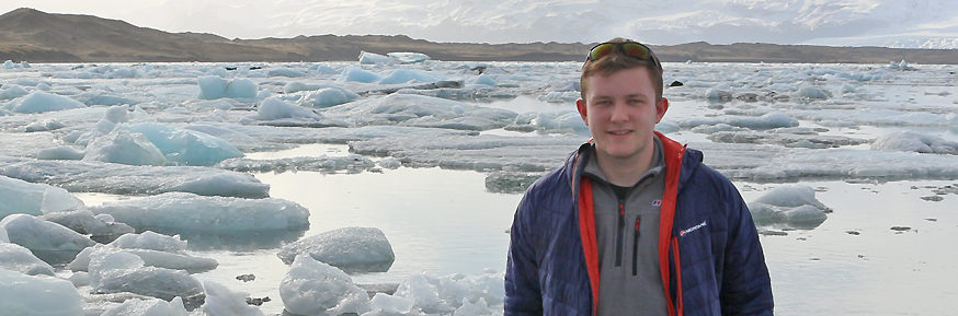
One of the most extraordinary sights of the trip came when visiting the Jökulsárlón glacier lake at the foot of Breiðamerkurjökull with countless icebergs floating in the lagoon. This really helped everyone on the trip to visualise how Iceland’s landscape is constantly changing and highlighted how melting of ice in Iceland could have global consequences.
The highlight of the trip for me was a glacier hike of Svinafellsjökull where we were able to look at the impact of glaciers from on a glacier itself whilst it was snowing - what more could a geography student want? We got a break from recording field observations in our notebooks and were able to relax … apart from when looking into large crevasses on the glacier!
On the final days of the trip we finished our fieldwork at lunchtime and headed to Reykjavík for the afternoon to do some sightseeing, including going inside the city's main landmark, the Hallgrímskirkja church.
The trip was an excellent experience, allowing us to apply the knowledge developed through studying geography at Lancaster University. There are many other fieldwork opportunities available to students in the Lancaster Environment Centre.
Disclaimer
The opinions expressed by our bloggers and those providing comments are personal, and may not necessarily reflect the opinions of Lancaster University. Responsibility for the accuracy of any of the information contained within blog posts belongs to the blogger.