

Featured Projects
Digging Into Early Colonial Mexico
A large-scale computational analysis of 16th century historical sources
(ESRC | CONACYT | FCT) 2017-2020
The Colonisation of America is a fundamental process in the history of the modern world. To date much research has focused on a close reading of a handful of the Relaciones Geográficas, one of the most important sources for the colonial history of America. Using a Big-Data approach, the Digging into Early Colonial Mexico project will apply novel computational methodologies to their analysis, and it will identify, extract, cross-link, and analyse information of vital importance to historical enquiry. In doing so, the project will transform the way historical sources are approached and analysed by modern scholars. (PIs: Patricia Murrieta-Flores, Lancaster University; Bruno Emanuel da Graça Martins, Universidade de Lisboa; Diego Jiménez-Badillo, Museo del Templo Mayor, INAH)
Chronotopic Cartographies
Creating a Chronotopic Ground for the Mapping of Literary Texts
(AHRC) 2017-2020
PI: Sally Bushell
The Chronotopic Cartographies project is about visualising literary place and space, using the digital medium in a way never before attempted to advance spatial understanding and interpretation of literary texts for a range of users. We will interpret texts and images by an iterative structure that connects visual and verbal representations and moves between them. We are interested in adapting gaming engines to explore space and place in canonical literary forms, creating a range of maps and 3D visualisations for different kinds of imaginative terrain and mapping at different scales. Our project will enhance knowledge and understanding of digital tools for the spatial humanities, literary mapping and for spatial approaches to analysis and interpretation of literary works.
Urban Heritage and the Digital Humanities in India
A Research Network for scholars and practitioners interested in the potential of digital technologies in scholarship, archives and heritage.
(AHRC) 2017-2019
PI: DEBORAH SUTTON
The Urban Heritage and the Digital Humanities in India Research Network will use Digital Humanities methodologies to review existing digital projects, generate strategies for the integration and analysis of existing urban heritage materials and for future documentation projects. A key outcome of the network is the creation of an app, safarnama, that will geolocate specific fragments of experience from the lives of refugees in the city in the late 1940s and 1950s. (PI: Deborah Sutton, Lancaster; Co-Investigator: Dr Hilal Ahmed, Centre for the Study of Developing Societies, Delhi.)
Encyclopaedia of Shakespeare’s Language Project
Bringing a new method of language research – the corpus approach – into the heart of Shakespearean studies
(AHRC) 2016-2019
The Encyclopaedia of Shakespeare’s Language Project brings a new method of language research – the corpus approach – into the heart of Shakespearean studies. It affords fresh insights into Shakespeare’s use of language at multiple levels – words, phrases, semantic themes, character profiles and more. It reveals what Shakespeare’s language meant to Elizabethans through the analysis of millions of words written by his contemporaries. The project will not only share the rich resources it produces to generate the encyclopaedia, but enable users to deploy them for their own purposes.
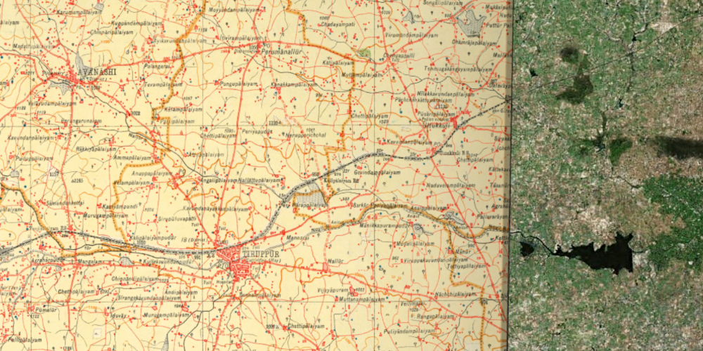
Digital Innovation in Water Scarcity in Coimbatore, India
A rapid, reflexive intervention in the ongoing, and worsening, water crisis in Coimbatore in Southern India
(AHRC GCRF) 2020-2021
PI: DEBORAH SUTTON
The project will use digital humanities methods to assemble data related to imaginaries, regimes and economies of water bodies over a 200-year period. Our aim is to create an urgent response to strained and failing strategies of water conversation policy and practise in Coimbatore, South India. The project is a collaboration between Deborah Sutton, T. Shanmugapriya and a number of local environmental activists which aims to establish a sustainable legacy of data for ongoing and subsequent development-led research in the region and beyond.
All Projects
A Digital Narratology of Technology as Literary Actors and Artefacts
(SPARC) 2020
PI: Deborah Sutton
Deborah Sutton is co-recipient of a Government of India SPARC award, a scheme that supports collaboration between Indian and non-Indian researchers. The project, ‘A Digital Narratology of Technology as Literary Actors and Artefacts’, is led by Professor Nirmala Menon from the Digital Humanities and Publishing Studies Research Group Indian Institute of Technology Indore, and is being supported as an Emerging Area of Impact in Digital Humanities research. The award will allow academic staff and postgraduate students from Lancaster University’s Digital Humanities Hub and IIT Indore to work together towards new innovations in Digital Humanities.
(Pelagios Small Grants) 2019
This project explored the use of digital annotation for analysing historical maps, specifically a corpus of maps produced in 16th century Mexico as part of the Relaciones Geográficas de Nueva España. We delivered a series of Citizen Science mappathons, where 30 scholars were trained in the use of Recogito and annotated a total of twenty maps. Going forward, there is a great deal of potential to expand this dataset and to explore alternative methods of analysis.
(Pelagios Small Grants) 2019
PI: Deborah Sutton
This project identified a range of high quality digitised maps of the Indian subcontinent. Six maps were selected for annotation, published between 1714 and 1894 and containing English, Dutch, French translations of Indian toponyms. Exploration of the completed dataset has the potential to trace continuities and discontinuities in the assignment of place-names and to gather clues about the transliteration of place-names.
(Department of History, Lancaster University) 2019
For this project, Raquel Liceras Garrido and Katherine Bellamy created a series of three ESRI StoryMaps, combining interactive texts, images and maps in a series of online interactive learning resources on the history, archaeology and geography of the Postclassic and Colonial period of Central Mexico, beginning in the 14th through to the mid-16th century. These resources look at the History of Mexico, Tracing Toponymy (exploring the nature of historic place-names) and Depicting Geographies (discussing methods of depicting space and place).
(Manx National Heritage) 2018
This project based at Lancaster University is a collaborative effort with Archaeovision, Knowledge Integration, Goii Limited and Manx National Heritage, looking to create for the first time a full digital corpus of 3D images of all 210 medieval crosses of the Isle of Man. This corpus will inform conservation measures, enable research at multiple levels and promote online engagement with the corpus. 3D images of these crosses are available to view online on Sketchfab.
The Reception of English Saints’ Shrines as Tangible Art: A Digital Barometer
(Paul Mellon Centre for the Study of British Arts) 2017-2018
This project created the first online interoperable public dataset of English shrine imagery —before, during, and after the Reformation. This also includes important textual research information such as geographic data, detailed descriptions and data on artists, sources and materials related to the shrines. The team is composed of historians, archaeologists, literary scholars and computer scientists. (PI: Patricia Murrieta-Flores; Team: Dr Ruth Nugent, Lancaster; Dr David Harry, University of Chester; Dr Naomi Howell, University of Exeter; Mr Matt Williams, Full-Design).
A Research Network (AHRC) 2017-2018
PI: Ian Gregory
This research network brings together two distinct fields that previously have had little interaction: Geographical Information Science (GISc) and Qualitative Spatial Representation (QSR). The aim is to explore whether a combination of approaches from the two can provide flexible ways of representing spatial information that are suited for Digital Humanities. The network brings experts from history, literary studies and archaeology together with experts from computer science, artificial intelligence and GISc. (Co-Investigator: Dr John Stell, University of Leeds)
(Leverhulme Trust) 2015-2018
PI: Ian Gregory
The Geospatial Innovation in the Digital Humanities project applied ground-breaking and exploratory digital methods to study accounts of the English Lake District, developing new understandings. It focused on a 300-year period between the eighteenth and twentieth centuries, a time that witnessed successive social, cultural, economic and industrial revolutions which impacted on the landscape and contributed to the area’s heterogeneous identity. To read more about the project, click here.
(Natural Environment Research Council) 2014-2018
The Historic Droughts project was a four year £1.5m project funded by the UK Research Councils. It developed cross-disciplinary understandings of past drought episodes that have affected the UK, with a view to developing improved tools for managing droughts in future. Lancaster’s primary role in this was using GIS and corpus linguistics to look at past droughts, assessing public discourse using two types of data: news media and social media. Datasets and publications produced in this project are available here.
(ESRC) 2013-2018
PI: Tony McEnery
CASS is designed to bring a cutting-edge method in the study of language – the corpus approach – to a range of social sciences, providing insight into societal use and manipulation of language in a host of areas: including education, hate crime and communication about health and illness. They are developing new approaches to understanding and addressing phenomena such as hate speech and the stigma associated with mental illness. We work closely with stakeholders from the public sector, industry and charitable organisations.
Visualizing Spatial Experience in the Holocaust
(National Endowment for the Humanities)
2016-2017
First-person accounts are central to understanding the Holocaust. This project used video interviews with survivors to analyse the language survivors use in speaking of places, events, movement, relationships, and their perceptions of space and time. It focused on how their social networks were fragmented and reformed, and the spatial characteristics of work places and work relationships experienced by forced laborers in ghettos and labour camps. The project used a hybrid methodology, combining close listening with spatial visualization and corpus and computational linguistics methods.
(COST)
2014-2017
PI: Howard Hotson
The postal revolution between 1500-1800 allowed ordinary people to scatter letters across and beyond Europe. This help create the Republic of Letters, a knowledge-based civil society crucial to the era’s intellectual breakthroughs. Ironically, the letters that created this community also dispersed the documents that created it. This project envisaged open-access, open-source, transnational digital infrastructure capable of facilitating the radically multilateral collaboration needed to reassemble this scattered documentation, supporting a new generation of scholarly methods and research questions.
(Heritage Lottery Fund)
2015-2016
The Streets of Mourning and Community Memory in Lancaster project created a community memory of the 1,055 “Men of Lancaster who gave their lives in the Great War”. This, in turn, allowed us to create an interactive website showing the impact of the War on Lancaster that includes interactive mapping of where the casualties lived and stories of how the War affected local communities. This project was a collaboration between the Department of History, Lancaster University, the Lancaster Military Heritage Group, the Lancaster Civic Society and the Lancaster King’s Own Regiment Museum.
(Newby Trust)
2014-16
PI: Ian Gregory
At Lancaster University we have access to 1.2 billion words of writing in English from 1475 to 1700 alone. This project examined the capacity of the corpus approach to the study of language to transform research in the humanities, with a particular focus on history. It built one of the largest integrated historical corpora ever created, using it to conduct an innovative analysis of changing attitudes to poverty and deprivation over time.
(European Research Council)
2012-2016
PI: Ian Gregory
This project aimed to create a step-change in how place, space and geography are explored in the Humanities. Building on our technical expertise in Digital Humanities, Corpus Linguistics and Geospatial Analysis, and expertise in the history of the English Lake District, we developed and applied methodologies for analysing unstructured texts—including large corpora of historical books, periodicals and official reports—within GIS. These were applied to sub-projects looking at topics such as Lake District writing and nineteenth century public health.
(British Academy)
2007-2008
PI: Ian Gregory
Mapping the Lakes was a pilot project to test whether Geographic Information Systems could be used to further understandings of the literature of place and space. The project mapped out two textual accounts of journeys through the landscape of the Lake District: Thomas Gray’s tour of the region in the autumn of 1769; and Samuel Taylor Coleridge’s ‘circumcursion’ of the area in August 1802. We provided GIS representations of these accounts and suggested ways in which the mapping process opens up spatial thinking about these geo-specific texts.
Collaboration
We already have a wide range of collaborations with organisations outside of academia. These range from work with major national institutions, to international networks, to small local heritage groups.
We have an international collaboration with the Pelagios Network, an initiative with academic, charitable and memory institutions partners from over 13 countries.

We have worked extensively with the British Library, using large digital corpora and currently have an ESRC CASE PhD studentship using British Library resources to look at 19th century immigration.
We work closely with tagtog, a text annotation tool powered by Artificial Intelligence, in a number of ways, including work on the Digging Into Early Colonial Mexico and ‘Co-creating the Future of the Past’ projects.

Locally, we have a long-standing collaboration with Lancaster Military Heritage Group that led to the Streets of Mourning website.
We work closely with Lancaster University’s Regional Heritage Centre, who foster engagement between Lancaster University and the regional community in the field of cultural heritage.

We have worked with the Wordsworth Trust on exhibitions and events, including the ‘By Duddon’s Side’ exhibit.
A collaboration made possible by the Government of India SPARC award, which allows academic staff and postgraduate students from Lancaster University’s Digital Humanities Hub and IIT Indore to work together towards new innovations in Digital Humanities.
We are keen to develop further relationships at international, national, regional or local levels.
These might involve collaborative PhD projects or collaborative funding bids, or more minor activities such as joint exhibitions, meetings or talks.
For further information please get in touch.