Dr Yani Najman organises a group of 32 scientists on a geological field trip across the Himalaya.
We are at the start point in Kathmandu, Nepal, and finally we are all assembled. Well, nearly all. One scientist has cancelled last minute after Legionnaire’s Disease in his lab has laid him low. Another one has only managed to get as far as his departure airport before he was denied boarding by overly-officious ground staff who noted an ‘irregularity’ in his passport. Two others, on fieldwork in Nepal in advance of the trip, are delayed as their transport has been commandeered to rescue trekkers recently caught in an extreme storm.
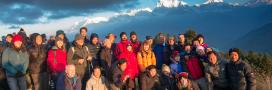
Our now slightly depleted party of 32 scientists is comprised of PhD students, post-doctoral researchers, and their supervisors from 11 different European research institutes. We are a mix of seasoned Himalayan field geologists, and “newbies” to the mountains, encompassing a range of specialities from deep-earth geophysics to climate modellers. We’ve been brought together by a European research consortium, iTECC, investigating Tectonic-Erosion-Climate Couplings.
This means that we are looking at the interactions between tectonism (deformation of the earth’s crust into mountains and other topographic features), erosion of these features, and climate. For example, formation of a mountain belt can cause a change of climate in the mountain belt’s rain shadow, and increased erosion through establishment of steeper slopes and increased rainfall on its windward side.
Bringing to life the geology of the mountains
Our natural laboratory is the Himalaya – an ideal place to study these couplings, since the uplift and erosion of the mountain belt resulted in strengthening of the monsoon, and may also have been responsible for past global cooling.
I am a deputy co-ordinator of the Consortium, in charge of training workshops, and this is the field workshop, the most logistically challenging I’ve organised so far. Our goal is to bring to life the geology of the mountain range that the group members are all researching, by traversing across the range from south to north, studying the rocks as we go.
We begin in the sweaty humid lowlands, looking at 15 million year old river deposits, which two of our Consortium’s students are studying to determine the weathering regime, monsoon intensity, and evolution of the mountain belt at that time. We soon leave behind the plains with its cute (albeit rabies-carrying) monkeys, less cute (malaria-carrying) mosquitos, heat and noise.
We head for the mountains in what is somewhat generously called a ‘semi-delux’ bus. The Nepalese are small people, and bus seats are sized accordingly. Luckily I’m small too, but the taller ones amongst us struggle to accommodate all their appendages within their allotted space.
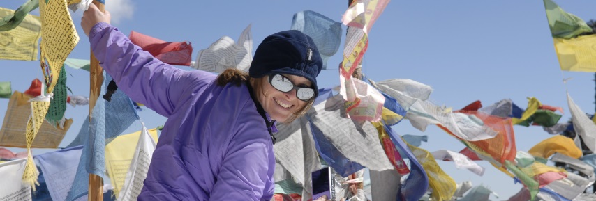
Our first view of the high mountains, the lofty snow clad Annapurna range, requires a photostop, and we gaze towards the peaks that formed as the result of the collision between India and Asia.
Presenting without powerpoint
The next day, we continue by foot. The first day’s trek involves a hefty climb, and we arrive in a very tired heap at the top, in no mood to study the geology. However, restored by a hot tea, we are ready to listen to the evening’s talk; each evening one student group presents the geology of the region we will walk through the next day. The students have to be resourceful as there are no laptops for powerpoint presentations. They do well, presenting by torchlight, al fresco, using a whiteboard that’s been carried up the mountain, along with all our gear, by pack ponies.
The next morning I’m too sick to walk. Our guide is unsympathetic, and tells me it’s because I walked up the hill too fast the day before. I know full well that the cause of the problem is his country’s ‘vibrant’ bacteria that no doubt lurked in yesterday’s dinner, but I’m in no mood to argue. Later that day I manage to walk slowly for the 6 hour trek to rejoin the group.
Collisions and near misses
Over the next few days we walk through folded metamorphosed rocks that have been highly deformed and altered by the heat and pressure associated with the collision between the continental plates of India and Asia. The students use different minerals to assess the temperatures and pressures attained in the rocks. We soak our aching muscles in natural hot springs that bubble up along faults in the crust that formed as a result of the plates’ collision.
For the one section where there is a road, we suffer the most hair-raising of bus rides. We lurch in a decrepit vehicle along a narrow track hewn out of the mountains and overlooking a precipice. One student takes her mind off the chasm below by using her compass-clinometer (meant for measuring rock slope inclinations) to determine how far the bus lurches from the vertical towards the precipice (up to 20 degrees she reports). Another spends his time praying to all the deities – luckily there are quite a few in Nepal.
Signs of the sea at 8000m
More walking takes us north of the range, and into the semi-arid region of the rain shadow where the monsoon rarely reaches and the vegetation is sparse. Here the rocks are sedimentary, and were deposited in an ocean that separated India from Asia before the collision. After collision, the rocks were pushed upwards, and this explains why there are marine fossils from the sea floor now found 8000m up at the top of Mt Everest.
The final day’s walk is tough. We are now at altitude, which makes breathing more laboured. Arriving spluttering at the pass, we are rewarded with the most amazing views of this superb range, and it’s all worthwhile – the highlight of the trip.
Then it is time to go down, and down and down and more down, until we meet up with a light plane that whisks us back to Kathmandu. We fly effortlessly over the peaks that so starkly represent the physical manifestation of one of the greatest plate collisions on earth.
Yani is currently on an expedition with IODP to the Indian Ocean, which hopes to find out more about the relationship between mountain formation and climate by drilling sediment from beneath the Bay of Bengal. She will be writing her next blog from on board ship.
Find out more about the IODP
Disclaimer
The opinions expressed by our bloggers and those providing comments are personal, and may not necessarily reflect the opinions of Lancaster University. Responsibility for the accuracy of any of the information contained within blog posts belongs to the blogger.