|
This slide-box index was created to give an overview of the images currently available in the on-line database. The thumbnails incidentally give a rapid visual tour of the type of terrain Fox passed through. They are arranged in that order. At the moment they are accessed from the texts of the Journals. They will in due course be linked from this index to the texts of the Journal and other documents. Some areas are not yet sufficiently covered, notably at the end of the period with the journey through Country Durham: this is under way. Most of the photographs were taken in the course of a series of expeditions, from 2005 onwards, researched and planned to follow the route taken by Fox as closely as possible. They are the © of the photographer. They are supplemented by a small choice of others, for which permission has been granted. Links are also made to other particulary useful websites. These external images do not appear in this index. Photographs are supplemented where possible by engravings which though not contemporary (Romantic landscape painting was not popular in Fox’s time, and it will be noticed that most of the paintings used to illustrate travellers are Dutch) in many cases show the terrain before it was built over with modern housing, or buildings before they were destroyed or radically altered. There are a few almost contemporary sketches by the Rev. Thomas Machell (1692) of Kirkby Thore. N.b. that the buildings are unlikely to be exactly those Fox knew: even if they are ‘original’, they will have been altered by later generations. Most are also private houses and/or working farms: please respect their privacy. Each image is Images are continually being added to this section. It is not to be considered as definitive. Click on image for enlargement. |

Pendle Hill from Wycoller |

Pendle Hill from above Burnley |

Pendle Hill from NE |

Pendle Hill panorama |

Pendle from above Barley |

Towards Ingleborough |

Old Well Hall, Downham |

Sawley Abbey |

Between Settle & Malham |

Pen-y-ghent from the south |

Hubberholme, Langstrothdale |

Scar House from Hubberholme |

Scar House, Langstrothdale |

Drove Road to Stalling Busk |

Countersett Hall |

Above Semerwater |

Wensleydale |

Askrigg |

Askrigg: St Oswald’s Church |

Cam High Road |

Cam High Road descends |

Pen-y-ghent from near Gearstones. |

Packhorse Bridge, Dent Head |

Barn in field, Dentdale |

Stonehouses, Dentdale |

Stonehouse Farm, Dentdale |

Upper Dentdale |

Garsdale |

Garsdale: Houses |

Grisedale towards Garsdale viaduct |

Grisedale |

Grisedale panorama |

Garsdale |

Garsdale: Baugh Fell |

Garsdale towards Sedbergh |

Brigflatts, where Richard Robinson lived |

Friends’ Meeting House, |

Friends’ Meeting House, |

Brigflatts, Friends’ Burial Ground |

Brigflatts, houses |

River Rawthey |

Borrett Farm |

Cross Keys, Cautley |

Ravenstonedale |

St Andrew’s, Sedbergh |

Yew tree, St Andrew’s, Sedbergh |

St Andrew’s Churchyard, Sedbergh |

‘Fox's Yew’, Sedbergh |

Sedbergh market place, old cross |

Sedbergh towards market |

Street, Sedbergh |

View from Heights of Winder |

Draw-Well |

Draw-Well Barn |

Draw-Well |

The Howgills from Draw-Well |

Draw-Well, storm approaching |

Firbank Fell from Draw-well |

Howgills from Firbank Fell |

Firbank Fell from North |

Firbank Fell from South-West |

Firbank Fell from the South |

Site of Firbank Chapel |

Firbank Chapel: |

‘Fox’s Pulpit’ |

‘A man preaching on a mountain’ |

‘Fox's Pulpit’ from the Chapel site |

Firbank Church |

Firbank ‘Auditorium’ |

Firbank looking south |

To Crosslands: Lune Valley |

Crosslands farm |

From Crosslands to |

Kent Estuary from Warth Hill |

Kent Valley |

Road to Gatebeck |

Preston Patrick over fields |

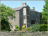
Preston Patrick Hall |

Preston Patrick Church |

Preston Patrick Church |

Camsgill |

Preston Patrick Church from Camsgill |

From Preston Patrick |

Preston Patrick Church |

North Road: looking back |

North Road: Field End Bridge |

North Road: Sellet Brow |

North Road: Crosscrake Church |

North Road: Crossroads by Crosscrake Church |

North Road looking back |

Sizergh Castle from |

North Road: Natland |

North Road: looking towards Kendal |

Kendal: Nether Bridge |

Kendal: Kirkland |

Kendal: Blind Beck |

Kendal: Holy Trinity Church |

Kendal: Holy Trinity Church 1691 |

Kendal Church Interior |

Kendal: Sandes Hospital |

Kendal, Moot Hall |

Kendal Market |

Kendal, Market Place |

Kendal from the Castle, 1832 |

Kendal Castle from the West |

Kendal Castle |

Kendal: The Fleece Inn |

Kendal: Black Hall" |

Kendal: Stramongate Bridge |

Kendal: Castle Dairy (Dowery) |

Kendal from Greenbank 1832 |

From Kendal to Underbarrow |

Furness Fells from |

Arnside from Scout Scar, 1835 |

Arnside from Scout Scar |

Underbarrow from Scout Scar |

Tullythwaite Hall, Underbarrow |

Underbarrow: green ride |

Underbarrow Church (1708) |

Moss at Underbarrow |

Road to Crosthwaite |

Crosthwaite panorama |

Bowland Bridge |

Woods on the way to Pool Bank |

Pool Bank |

‘Fox’s Pulpit’ Pool Bank |

Whitbarrow Scar |

Winster Valley |

Old Meeting House at Height |

Tow Top Road |

Newton-in-Cartmel |

Staveley in Cartmel |

Bay Crossing from |

Lindale Church |

Field Broughton from High Newton |

Towards Newby Bridge |

Newby Bridge |

River Leven |

Above Causeway towards |

Towards Causeway |

Causeway |

Bouth |

Bouth Old Hall Farm |

Colton Church |

Colton panorama |

Tottlebank Baptist Church |

North towards Penny Bridge |

Greenodd Sands |

Leven Sands by the A590 |

Ulverston and the Leven Estuary |

Swarthmoor Hall |

Fireplace in Great Hall |

Hoad Hill from Swarthmoor |

Ulverston Church |

Sandys memorial |

Plumpton_Hall |

Leven Estuary below Plumpton |

Ulverston, panorama |

Morecambe Bay |

Aldingham Church |

Aldingham Churchyard |

St Michael’s Rampside |

Rampside |

Piel Castle |

Furness and Walney |

Dalton Castle |

Dalton Main Street |

Walney Island Offshore Wind Farm |

Walney Island Channel |

Baycliff |

Dendron |

St Matthew’s, Dendron |

Swarthmoor Hall |

Swarthmoor Hall |

Crossthwaite: outlying farms |

Firbank Fell, Howgills, and |

Brigflatts fields looking |

Up Garsdale towards Grisedale |

Swarthmoor orchard |

‘Fallen Yew’, Underbarrow |

Lancaster Castle |

Lancaster, c. 1770 |

Lancaster Castle & Priory Church |

Lancaster Street Market |

Friends’ Meeting House, Lancaster |

Lancaster Priory Church |

Lancaster Priory Church: Tower |

Lancaster Priory Church: interior |

Lancaster Priory Church: |

Down Church Street from the Priory Church |

Lancaster Castle & Priory Church |

John Lawson’s tombstone, |

Halton Church with Anglo-Saxon Cross |

Halton Church across the Lune |
Kendal Market Place |

Underbarrow |

Ulverston Sands |

Swarthmoor, balcony |

Ulverston Market |

Black Combe & Walney Island |

Cocken, Barrow |

North Scale from Barrow |

Walney Channel: mud & stones |

Rampside |

George Fox’s travelling bed |

Yealand Conyers Friends’ Meeting House |

Ingleborough across harvest fields |

Northwards from Yealand Conyers |

John of Gaunt’s Gateway, Lancaster |

Lancaster Castle, Main Gate |

Lancaster Castle |

Judge Thomas Fell |

Lancaster Old Bridge |

Over Kellet |

Over Kellett: |

Fields between |

Borwick Hall |

Fields from Over Kellet |

Morecambe Bay Sands from Hest Bank |

Bay Walk from Hest Bank |

Sands Guide Royal Charter 1728 |

Turner: Crossing the Sands |

Milestone, Cartmel |

Ulverston and Cartmel Sands |

Ulverston Sands, Canal Foot |

Ulverston Sands, beginning of crossing |

Ulverston Sands crossing, warning |

Bay from Hest Bank, stormy weather |

Bay downstream, tide coming in |

Devil’s Bridge, Kirby Lonsdale |

Bridge at Crook of Lune, Beckfoot |

Grayrigg |

Hill at Grayrigg |

Cartmel Priory across the fields |

Cartmel Priory |

Cartmel Priory |

Cartmel Priory interior |

Cartmel Priory: Creed panel |

Gleaston Mill |
Swarthmoor |

Arnside Tower |

Kent Estuary from Arnside Knott |

Kent Estuary from Cartmel Fell |

Arnside Knott from Cartmel Fell |

Ash House |

Marsh Grange |

Marsh Grange |

Marsh Grange |

Marsh Grange |

Black Combe and Duddon Sands |

Swarthmoor: bed |

Cary 1794 map: Duddon routes |

Millom from Askham |

Millom from Tippins Lane |

Road: Pennington to |

Top of Kirkby Fell |

Looking back at Kirkby Fell |

Duddon Sands from Kirkby Fell |

Kirkby in Furness |

Descent |

Kirkby Hall |

Broughton in Furness |

Broughton-in-Furness, Village Stocks |

Head of Duddon Sands |

High Cross Inn at head |

John Cary 1794 Map |

Road to Whicham |

Black Combe at Whicham |

Silecroft |

Bootle Church |

Duddon: Railhead and |

Hill Road over Bootle Fell |

Fells above Bootle |

Green Ride from Bootle Fell |

Bootle and the Isle of Man |

Bootle Church |

Mist on road to Corney |

Sheep on Bootle Fell |

Fog on road to Eskdale |

Eskdale from Muncaster |

Muncaster Bridge over the Esk |

Muncaster Castle |

Gosforth Church and Cross |

Egremont Castle |

Pardshaw Crag |

Pardshaw from the Crag |

The Northern Lakes Hills near Pardshaw |

Brigham Church |

Brigham Church and yew trees |

Brigham Church across the Derwent |

Cockermouth 1832 |

Cockermouth Church |

River Cocker |

Cockermouth Castlegate |

Cockermouth Main Street |

Embleton, the church |

Embleton, the field |

Embleton churchyard |

Mosser Chapel |

Mosser Belfry |

View North from Mosser Chapel |

Cow at Mosser |

Haltcliff Hall |

Haltcliff Hall date slab |

Caldbeck Fells |

Caldbeck Fells panorama |

Wigton, Victorian Market Cross |

Carlisle Castle and Irish Gate |

Carlisle Cathedral |

Carlisle Cathedral 1802 |

Carlisle Castle |

Carlisle Castle 1835 |

Carlisle market place |

Carlisle Market Cross |

Carlisle Citadel 1803 |

Carlisle Citadel today |

Carlisle English Gate and Prison |

Carlisle from the north-west |

Wilfrid Lawson’s house |

Brigham Church |

Caldbeck St Kentigern |

Great Strickland towards the Pennines |

Great Strickland Friends Meeting House |

Great Strickland Church |

Orton |

Appleby |

Stainmore above Brough |

Stainmore |

House on Stainmore near the summit |

Stainmore towards Bowes |

Lower reaches of River Derwent, |

Hexham |

Hawkshead Grammar School |

Hawkshead Grammar School Classroom |

Hawkshead Grammar School Desktop |

Hawkshead Church |