
On the tenth anniversary of Hurricane Katrina, coastal scientist Dr Suzi Ilic remembers visiting New Orleans and seeing first hand how the management, and mismanagement, of a coastline can effect lives.
The view from the plane approaching New Orleans revealed miles of coastline, made up of a patchwork of green and blue surfaces. What struck me was the lack of significant boundaries between swamps, wetlands and the sea and how fragile and interdependent this system is. These green areas are the only natural protection from the sea.
The city was still recovering during my visit in May 2007. I was attending the Coastal Sediment Conference, which provides a forum for scientists from around the world to discuss advances in our understanding of the physical processes involved in the creation and movement of coastal sediments, and resulting changes to coastlines. It could not have been held in a better place.
A city built on sediment
In New Orleans both past and future are closely connected with the movement of sediment in the Mississippi River and the Gulf of Mexico. French colonists built the settlement we now know as New Orleans in the early 18th century on natural high ground formed from deposits of sediment brought down by the Mississippi River. For centuries the city was naturally protected by those sediment deposits and the wetlands of the Mississippi Delta.
Then the city started to expand into low-lying areas. Flood protection work on the Mississippi River reduced the supply of sediment and subsidence in the city was intensified by the extraction of water nearby. These made New Orleans vulnerable to coastal flooding when water levels rose during tropical storms.
In August 2005, Hurricane Katrina, one of the deadliest storms in US history, reached the Louisiana Coast. I remember listening to a BBC reporter urging people to drive out of New Orleans and wondering how those who did not have cars would be evacuated.
At the conference, Mitch Landrieu, at that time the Lieutenant Governor of Louisiana and now mayor of New Orleans, gave a passionate keynote talk. He introduced us not only to the natural and historical settings of the city and its national economic importance, but also told us about what happened during and after Hurricane Katrina.
Talking to the residents
As we explored the city, everyone was welcoming and willing to share their experiences during Katrina. They were all unhappy with the Federal Emergency Management Agency (FEMA) and its slow response to the disaster: there were even T-shirts expressing this dissatisfaction.
We spoke to restaurant and shop owners around the French Quarter. There, the ankle high water level did not affect their premises, but they were still suffering from reduced business and were eagerly waiting for tourists to return to the city.
The city centre was coming back to life. On Canal Street the only reminders of the Hurricane were a few bent signs and lamp posts and the Superdrome, where people sheltered during the Hurricane, in the background. Shop windows, which were looted a few months earlier, looked new and inviting. Walking through the Garden District, everything looked normal apart from buried and overgrown tram rails and wooden houses built on stilts.
A divided city
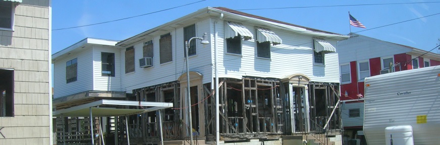
A technical tour around New Orleans exposed striking differences in the recovery of different parts of the city. In the Gentilly and areas around Lake Pontchartrain, areas badly affected by flooding, many houses were still borded-up or were in the process of repair, and people were living in caravans. This area is much lower and it was flooded by the increased water level in the lake forcing water down the main canals, breaching the levees.
I have lived in the Netherlands and, looking at these levees, it struck me that they looked low in comparison to the dykes that protected my home there. The levees were designed for a one in a hundred-year event, rather than the one in ten thousand year event envisaged in the Netherlands.
Our host took a couple of us around the Lower Ninth Ward, which was one of the most affected areas. The majority of residents here were African-American and displaced as far as Huston in the days following Katrina.
The Ward still had no electricity or water services and houses were deserted. The area is perceived to be dangerous, so our host took us around in a locked car, which we did not leave.
We saw hardly any residents and many houses still had the signs painted on them by the rescuers, showing how many living or dead people were found in them. It was like a ghost town and very moving, leaving us speechless.
Back in the French Quarter however, people were optimistic and, as one local musician told us, “give us 5 years and we will recover”.
Improving future flood protection
As well as exposing societal inequalities, the hurricane exposed the vulnerability of the current levees and pump stations, and the inadequate management of natural hazards. It became obvious that more care will need to be given to natural protection, such as wetlands, in the future.
Ten years later, many things have started to change, with New Orleans returning to its Big Easy image. Hurricane Katrina had a large impact not only on the fabric of the city and on the science and planning of coastal engineering but on society as well. Many lessons were learned about how to prepare for disaster, relevant far beyond New Orleans.
However many challenges are still ahead including adjusting to a changing climate, managing protection from and mitigation of natural hazards, and the ever increasing needs for funds to achieve these.
Disclaimer
The opinions expressed by our bloggers and those providing comments are personal, and may not necessarily reflect the opinions of Lancaster University. Responsibility for the accuracy of any of the information contained within blog posts belongs to the blogger.